Monday, September 25, 2023

Residential wood smoke from home-heating on the rise

It's gotten cold out there!  Autumn is finally here and with that comes cooler weather and the need to heat homes.  Residential wood smoke from home-heating should be expected, especially at night and in the mornings when woodstoves and other wood-burning devices are regularly used.  Temperature inversions and light winds can cause smoke to stagnate, especially in valley communities.  This blog is intended to focus on wildfire smoke, but forecasts will be issued by Local Clean Air Agencies on their own sites and on AirNow.  As the season progresses, the National Weather Service may issue Air Stagnation Advisories and clean air agencies may initiate air quality burn-bans posted on their web pages, though we usually don't see those until November. 


Wednesday, September 20, 2023

Favorable Wildfire Smoke Outlook; Prescribed Fire Season Starting!

Recent rainfall and cooler temperatures limit smoke production on active wildfires

It certainly appears that wildfire season in Washington is winding down! A series of two cold fronts swept across the state on Monday and Tuesday, with the latter bringing cooler temperatures and rainfall to most areas of the state. As the westerly winds picked up ahead of the cold front on Tuesday, some individuals reported smelling smoke in the Seattle/Everett/Mt. Vernon corridor. This was likely a result of the still-smoldering fires in the Olympic Mountains, but air quality remained Good at all locations! 

Speaking of the fires in the Olympics, the Delabarre Fire has burned 3,658 acres as of September 19th, narrowly edging out the 2018 Maple Fire (3,273 acres) and the 2015 Paradise Fire (2,791 acres) to become the largest fire in the Olympic Mountains since the Great Forks Fire of 1951. Below is a map of all fire perimeters in the Olympic Mountains from 1951-2023, with the Delabarre Fire highlighted. Fortunately, the recent rainfall and cooler temperatures should limit any further growth of the incidents on the Olympic Peninsula. 


The other major smoke producer in Washington over the past month has been the Airplane Lake Fire, which has consistently funneled smoke into the Leavenworth/Wenatchee Valley. This fire also saw rain yesterday, though less than the Olympics. It is possible that with warmer weather on Thursday and Friday the Airplane Lake Fire may perk up a bit, but winds will be out of the east, providing the aforementioned areas with relief from the smoke. Some elevated smoke will likely be transported toward the Puget Sound, but I do not expect enough burning activity to produce any impacts above occasional MODERATE readings. 

Looking ahead to the weekend and early next week, I expect our first widespread heavy rain event to impact all areas along and west of the Cascades beginning Saturday and continuing through the first several days of next week. A true Washington Autumn classic, winds will be gusty and several periods of rain are expected. Below is the total precipitation forecast from NOAA's Weather Prediction Center through Wednesday morning, and you best believe this will tamp out any wildfire smoke concerns for the foreseeable future! Currently, the heaviest rainfall is expected on Monday and Tuesday. 


As wildfire season winds down, prescribed fire season picks up. Prescribed fires also produce smoke concerns, but the smoke is much shorter lived and burns are regulated to minimize air quality impacts across the state. The goal of prescribed fires is to promote a healthier, more wildfire resistant landscape, and are a very important tool in reducing wildfire danger to communities across Washington. If you live near US Forest Service or Washington DNR managed lands, follow your local USFS or DNR offices on social media to stay up to date on any planned burns in your area! 


Friday, September 15, 2023

Outlook: good air quality and localized smoke impacts

 The majority of the state continues to experience good air quality and low fire danger. A very clear satellite image from this morning--only the smoke plumes from the Airplane Lake Fire and agricultural burning in SE WA are visible, as well as smoke in Oregon):


The Airplane Lake Fire continues to cause intermittent smoke impacts around the Lake Wenatchee area and into the Wenatchee Valley, impacting the communities of Leavenworth, Cashmere, and Wenatchee. These intermittent smoke impacts will continue until the next significant precipitation event. There is potential for light smoke impacts today in East Snohomish County, but winds from the west this weekend will push any smoke east of the Cascades.

Across the rest of the state, fires in the Cowlitz Complex comprise almost 700 acres and are partially contained. Smoke from these fires is not expected to impact nearby communities. The Sourdough Fire continues to intermittently impact areas close to the fire in the Ross Lake National Recreation Area. There are also a few fires currently burning in the Olympics that were ignited two weeks ago by lightning strikes. Smoke from these fires (including the Eagle Point and Low Divide Fires) may intermittently impact Port Angeles and higher-elevation areas around Port Angeles. 

Weekend outlook: warm and dry conditions are forecasted for the weekend, but we're not expecting any significant new fire activity. Increased smoke from any local fires and prescribed burning may cause localized moderate air quality levels. Forecasted high winds across Central and Eastern Washington along with the dry conditions can lead to rapid fire spread; please continue to recreate responsibly.


-----------------------------------------------------------------------------------------------------------------------------

Taking a look back at our air quality this wildfire season, below is a plot of observed daily air quality levels for each day in each county in the state where there is an air quality monitor. Each row corresponds to the daily average at the most impacted monitor observed in each county on a given day. The major events we saw this wildfire season are highlighted--smoke from the Alberta fires in May, smoke from the Cascades and Southern BC fires in August as well as local fires in Spokane, and smoke from fireworks on the 4th of July. 


And how does this season compare to previous years? If we look at a timeseries of PM2.5 concentrations averaged across the state during wildfire seasons over the past 10 years, this year we saw smoke impacts in August, which is pretty typical. In previous years, easterly wind events have contributed to large smoke events in September and October. While it's only mid-September, that seems increasingly unlikely to occur this year, thanks to the recent cool temperatures and precipitation in the region and the low number of active fires in the Cascades.


Friday, September 8, 2023

Good air quality and low fire danger

Despite good air quality in most of the state, the Airplane Lake fire still has active hot-spots and is producing smoke that's been impacting residents around Lake Wenatchee.  Intermittent moderate smoke is also affecting the nearby communities of Entiat and Cashmere.  The Airplane Lake fire has only grown 200 acres over the past few days, but the fire is uncontained and will continue to produce smoke until the next wetting rains occur, which are not expected anytime soon.  

A wind shift is expected tonight, and moderate smoke from the Airplane Lake fire is expected to impact mountain towns in Snohomish County (such as Darrington) over the weekend.  That shouldn't last long though, as westerly winds are expected to pick back up on Sunday afternoon.

The Sourdough fire near the Ross Lake National Recreation Area is partly contained and has not grown much at all, prompting officials to reopen some trails and camps in the area.  Smoke from the fire has been minimal and intermittent, with no large hot-spots detected recently.

Other fires of note in Washington are in the Cowlitz Complex, with 700 acres burned across several fires.  Despite partial containment, there is still moderate fire behavior at the Snagtooth, Spencer Quartz, and Grassy Mountain fires.  No significant smoke has been detected in the area so far, but sensors are sparse in the region.

Fire danger remains too low for much risk of new significant fires in the coming days. The majority of our wildfire season has passed, and we don't expect any big flare-ups.   Since air quality and fire weather are not a concern, agricultural burning in the Columbia Basin and Idaho has begun.  Residents near agricultural communities from Yakima to Whitman county will likely see intermittent moderate smoke from agricultural burning through the month.

Smoke from the Airplane Lake Fire (image courtesy of 610KONA.com)


Thursday, August 31, 2023

Rain to the rescue: Smoke in Vancouver and the Weekend Outlook

Smoke from the Camp Creek Fire is funneling into the Vancouver area this morning. Air quality monitors in Vancouver observed elevated concentrations of PM2.5 starting around 3am. Air quality should improve today with the rain, but the pattern may repeat itself tomorrow morning. The Southwest Clean Air Agency has issued an Air Pollution Advisory for Clark County today through tomorrow afternoon due to intermittent unhealthy smoke impacts.


As for the upcoming weekend, recent rain has moderated smoke production from local fires, and more rain is coming thanks to a new frontal system. Colder temperatures and more moisture bode well for decreasing fire potential from any new lightning starts. Check out the forecasted total precipitation for the region through Sunday evening:


Forecasted winds from the north Friday and into Saturday will transport Canadian smoke down into Okanogan Valley. The area may observe intermittent moderate air quality. Smoke from the Airplane Lake Fire is also causing moderate to unhealthy air quality in the Lake Wenatchee area, which may continue through the weekend before more rain arrives on Sunday. Other than that, minimal smoke impacts are expected throughout the state this weekend. For areas close to fires, check out the smoke outlooks tab for updates. Enjoy the (mostly) good air quality!

Thursday, August 24, 2023

Regional haze dispersing, but several fires still causing local smoke impacts

Satellite imagery shows the remnant wildfire smoke haze dispersing this morning, but some fires are still producing visible smoke plumes.  We also expect easterly winds over the next few days and a Red Flag Warning is in effect for the West Cascade slopes of Lewis, Pierce, and King county due to dry and windy conditions.  With the expected wind shift, a moderate amount of BC smoke is expected to drift down into the Puget Sound region this weekend.  No Air Quality Alerts are planned at this time, but Moderate to USG smoke will likely impact northern counties for a couple days.

Residents in Okanogan have been living with intermittent smoke from nearby BC fires for quite some time, and that will continue.  The fires in British Columbia continue to dwarf what is going on in our state.  However, a low pressure system is expected to cause rain showers across the Pacific Northwest on Tuesday, and this should help limit temperatures and smoke production across the region.  BC officials also report that there has been good progress on containing fires and some evacuees are being allowed to return home.

The Airplane Lake fire (2,300 acres) in the Glacier Peak Wilderness Area of Chelan County has been pushing smoke into the Wenatchee region.  However, winds are shifting and Snohomish County communities like Darrington and Gold Bar will probably smell smoke over the next couple days. There are trail closures in the area around the fire.

The Sourdough fire (6,000 acres) in Whatcom County near Ross Lake is partially contained and firefighters report that opening SR-20 to thru traffic was a success.  However, sensors around the Diablo Lake region are showing intermittent smoky conditions and trail closures are still in effect.

The Oregon fire in Spokane County is partially contained and firefighters continue to make great progress.  Very little smoke is being generated at this time.

See the Health Information Tab on this blog for more information about how you can protect yourself from wildfire smoke.  See the Local Smoke Outlooks for detailed forecasts in your area.  Check WatchDuty for frequently updated information on local fires.

Smoke from the Airplane Lake Fire on August 22, 2023; courtesy of Inciweb

*** Update***

The Lookout Fire in Oregon is pushing smoke high into the atmosphere and being transported to the north, contributing to the haze over the region.  Fire crews have progressed with firing operations designed to strengthen control lines, and fire growth has been considerable, contributing to the large smoke production.

Monday, August 21, 2023

Statewide smoke update: clearing in Western WA today, smoke impacts in Central and Eastern WA continue this week

Over the weekend, nearly every part of the state experienced smoke impacts, with many air quality monitors observing unhealthy or worse conditions. Sunday's satellite image shows the swath of smoke across the state:

20 Aug 2023 19:01Z - NOAA/NESDIS/STAR GOES-West

Easterly winds plus smoke from both local and Canadian fires led to the poor air quality we observed over the weekend. Two fires in the Spokane area (Gray Fire and Oregon Road Fire) led to hazardous air quality in Spokane.

Outlook:

Western WA

We're already seeing improvements in western Washington with the arrival of westerly onshore winds. The smoke will likely linger through today but skies should be clear by tomorrow morning. Air Quality Alerts are in place through midnight tonight for the following counties: Island, King, Pierce, San Juan, Skagit, Snohomish, Whatcom. An Air Quality Alert is in effect until 5pm today for Clallam County.

Central and Eastern WA

Air quality will also slightly improve today in Central and Eastern Washington with southeast winds, although there is uncertainty in how much relief Central Washington will experience. Forecasted southwesterly winds tonight and tomorrow will increase smoke in the region. Air Quality Alerts comprise all Central and Eastern WA counties, and are extended through noon on Wednesday. 

Expect significant clearing on Wednesday.  Unfortunately, forecasted northerly winds could bring Canadian smoke to Northern Washington on Thursday and Friday. We'll update the blog as necessary.

____________________________________________________________________________________________

We observed interesting smoke dynamics in the atmosphere on Saturday as the smoke was transported higher up in the atmosphere but then mixed down to the surface. Ecology's air quality sensor at the Mt. Rainier visitor center (elevation 5400') observed elevated PM2.5 concentrations 3 hours before the closest purple air sensor at Longmire (elevation 2700') and 8 hours before the purple air sensor in Ashford (elevation 1700').


Saturday, August 19, 2023

Spokane County - State of Emergency

Spokane County is under a State of Emergency due to two large fires that have each burned approximately 10,000 acres: the Oregon Road Fire near Elk and the Gray Fire in Medical Lake.  Many homes and structures have been lost and the fires are still very active.  Spokane Emergency Management has information on evacuations and other important notices.  Evacuation Shelters are available at Riverside High School and Spokane Falls Community College.

Current air quality is very unhealthy to hazardous due to both local and regional fires.  Continued fire activity and region-wide smoke will continue to cause poor air quality until at least Monday.  However, the remnants of Hurricane Hilary will likely push welcome moisture into the region late Monday and Tuesday, which will help clear the smoke and hopefully help with fire suppression.  

When air quality is very unhealthy or worse, everyone should reduce exposure. Stay inside and filter indoor air to keep it cleaner. Go elsewhere for cleaner air, if needed. See the Health Information Tab on this blog for more information about how you can protect yourself from wildfire smoke.  See the Local Smoke Outlooks for detailed forecasts in your area. 

Fires around Spokane with recent satellite hot-spot detects in orange (8/19/2023 - Source: WatchDuty)


Friday, August 18, 2023

Wildfire smoke impacts in Western Washington this weekend

Recently a westerly wind pattern has been blowing wildfire smoke to the east and keeping it out of Western Washington.  However, winds will shift overnight tonight to easterly – funneling smoke from fires in the Cascades and southern British Columbia into the Puget Sound region.  All of Western Washington may be impacted – with the possible exception of the Olympics/coast.

Forecasted Unhealthy air quality for 5am Sunday

The air quality index is expected to reach Moderate or Unhealthy For Sensitive Groups on Saturday, increasing throughout the day.  Northern counties will be affected first as smoke travels southward.  Continued smoke movement on Sunday could lead to Unhealthy or worse air quality.  Light westerly winds on Monday and stronger westerly winds on Tuesday should help clear out the smoke.

An Air Quality Alert is being issued for the following Western WA counties, beginning Saturday at 9am and continuing through Monday at noon: Clallam, Clark, Cowlitz, Island, Jefferson, King, Kitsap, Lewis, Mason, Pierce, San Juan, Skagit, Skamania, Snohomish, Thurston, Wahkiakum, and Whatcom. 

While air quality in Central and Eastern Washington has improved today, northerly winds this afternoon will lead to declining air quality conditions that will continue through the weekend. Air quality alerts remain in place until Monday morning.

Limit your exposure by staying indoors, keeping your windows closed, and using air purifiers.  Track the current air quality on the smoke map at the top of this site.


Thursday, August 17, 2023

Smoke impacts in Central and Eastern WA through the weekend

Smoke from local and Canadian fires is impacting air quality in Central and Eastern Washington, as seen on this morning's satellite image:

GOES-West 17Aug 2023 15:31Z

Conditions will improve somewhat tomorrow as westerly winds push the smoke away, but relief will be short-lived as the winds shift to bring smoke back into the region Saturday evening. It's likely to be smoky in most of Central and Eastern Washington through the weekend, ranging from Moderate to Unhealthy conditions. 

There is an active Air Quality Alert for Central and Eastern Washington counties that extends through the weekend until Monday morning.

Critical fire weather continues across the state in this hot and dry weather. Active fire detections are shown in the map below.


We're also keeping an eye on the forecast for western Washington this weekend and will update the blog as needed. Easterly flow could transport smoke to the area, but as of now it's uncertain how much smoke will be transported.

As always, check out the smoke forecast and current air quality conditions in the map at the top of this page, and review DOH's tips for finding cleaner indoor air

Wednesday, August 16, 2023

It’s that time of year again to find cleaner indoor air

Wildfire smoke is increasing in our state, which means we need to start taking steps to reduce our exposure and protect ourselves. Breathing in wildfire smoke can cause health problems, even if you are healthy.

  • Limit duration and intensity of outside physical activity. 
  • Stay inside with cleaner indoor air: 
    • Close windows and doors, unless it is too hot to maintain safe temperatures. 
    • Don’t add to indoor air pollution by smoking cigarettes or burning candles inside. 
    • Filter indoor air through an HVAC system, HEPA portable air cleaner, or a DIY box fan filter. 
  • Set air conditioners to re-circulate. 
  • Seek clean air elsewhere if it is not possible to keep the air in your home clean or cool. 
  • If you must be outside, wear a properly fitted, NIOSH-approved particulate respirator, such as an N95 mask. 


For more information see the Health Information Tab or visit WA DOH’s Smoke from Fires webpage

Tuesday, August 15, 2023

Critical Fire Weather and Active Fires in North Cascades Increase Smoke Production this Week

Westside Smoke Relief Tomorrow, Eastside Impacts Increase

Unfortunately, our hot and dry weather has led to increased activity on several fires in the Northern Cascades. Remote weather stations near the Sourdough Fire topped out at 100 F yesterday afternoon and the heat is only expected to increase today. Critical fire weather will continue for the next few days. Hot and dry conditions will persist in the interior through Friday, while strong westerly winds will impact the Cascades this afternoon and all of Eastern Washington on Thursday. With all these threats, resources are spread thin, so practice fire safety to keep the workload on our firefighting teams as low as possible!

Currently most smoke in Washington is coming from the Sourdough Fire and the Dome Peak Fire, which is located in mountainous terrain north of Glacier Peak. Dome Peak was ignited in the same lightning storm as Sourdough and remained quiet until the hot weather this week allowed it to start flaming. There is also some smoke entering the state from fires in southern British Columbia and the Idaho panhandle. An Air Quality Alert is being issued for Chelan and Okanogan counties that will extend through Friday.


The Sourdough Fire continues to burn in heavy timber along State Route 20 with significant growth potential forecasted for the rest of the week. The Dome Peak Fire northeast of Glacier Peak recently sparked up and is showing no signs of calming down through the rest of the week. Both fires are located near the Cascade Crest, so the wind direction will be very important in determining which side of the mountains see the most smoke.

Today will be the last day of significant smoke impacts for most of Western Washington. Later today, onshore flow will resume which will push most smoke east of the Cascade crest. This will cause smoke to flow down mountain valleys on the Eastern Slopes such as the Methow and down Lake Chelan. The Methow Valley will be an area of concern for the rest of the week with up to Unhealthy air quality through Friday. Areas near existing fires like Newhalem and Stehekin will see Very Unhealthy to Hazardous conditions, especially at night, when smoke gets trapped near the surface. Chelan could see up to Unhealthy for Sensitive Groups for the rest of the week as well, while Moderate impacts are expected for Waterville, Darrington, and Concrete. Below is a depiction of smoke transport for the next 24-72 hrs.


Another concern is northerly winds through the Okanogan Valley channeling smoke from British Columbia towards the Columbia Basin overnight tonight and tomorrow. Similarly, smoke from the Ridge Creek fire in Idaho may be channeled west towards Spokane. These events will result in Moderate air quality for the Omak and Spokane areas through Wednesday, though impacts should subside for Thursday and Friday.

With mid and upper-level winds out of the west for the remainder of the week, elevated smoke will be visible across most of eastern Washington. As always, critical fire weather greatly increases the likelihood of new fires popping up statewide. If any new fires do crop up, smoke will be pushed east, so Eastern Washington will be primarily impacted. 

Jared McGlothlin
Wildfire Meteorology
Washington Department of Natural Resources

Sunday, August 13, 2023

Sourdough Fire Rises After Rainfall; Smoke Impacts Focused on Westside through Tuesday

 A critical week of fire weather lies ahead 

After widespread wetting rains fell across Washington early last week, it was discouraging to see the Sourdough Fire start producing smoke again yesterday. Last Monday was a great reminder that the damp greyness of Autumn is on the horizon, but fire season is still upon us and will be for the better part of the next month and a half. A mid-August heatwave begins today across the Pacific Northwest, with very hot and dry conditions expected through the workweek. The Northwest Coordination Center raised their preparedness level to 4 (out of 5) this weekend, indicating that an increase in fire starts is likely and that firefighting resources are starting to be stretched a bit too thin. It is crucial that we all work together to limit any new sparks this week! 

Fire danger will evolve in two stages this week: First, areas west of the Cascades will see a peak in fire danger Sunday-Wednesday morning. After Wednesday, onshore flow will return west of the Cascades and critical fire danger will shift east of the Cascades. This also mirrors smoke impacts for the week. Red Flag Warnings are flying for the west slopes of the Cascades through at least Monday evening. 


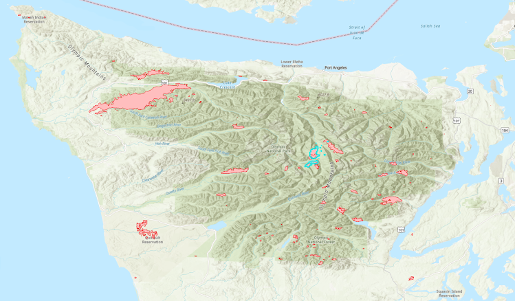
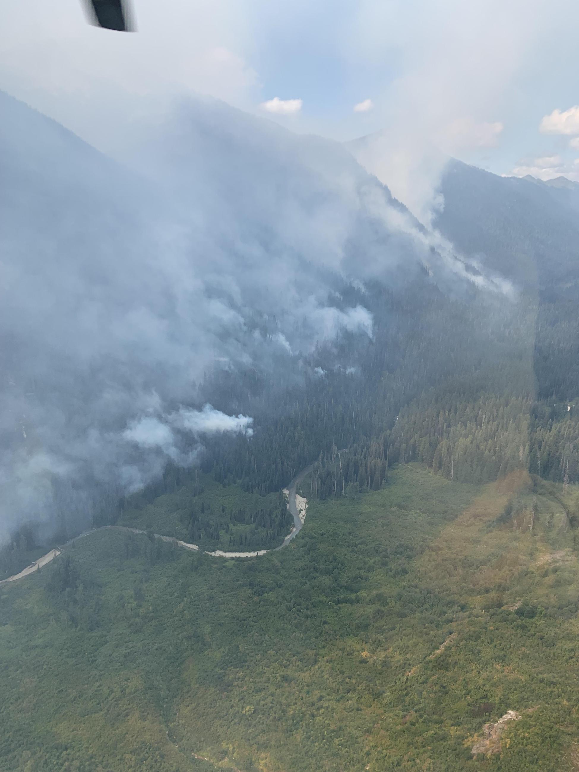
As of Sunday morning, the only fire-of-concern from a smoke perspective in Washington is the Sourdough Fire burning above Diablo Lake in the North Cascades. 


Prevailing winds through Tuesday evening will be out of the northeast across the Cascades and out of the north through the Puget Lowlands. The poorest air quality will be in the morning hours in the immediate vicinity of the fire and southeastward through the Skagit Valley. AQI values each morning will range from Very Unhealthy near the fire in Newhalem to Unhealthy for Sensitive Groups in Marblemount to Moderate in Concrete. 

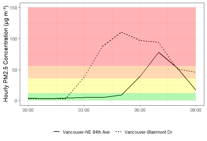
Ceilometer data from Puget Sound Clean Air shows that the smoke exiting the Skagit Valley and spreading to the east and south in the Puget Lowlands is primarily above 3,000 feet, which will limit air quality concerns to Moderate in the I-5 corridor north of Seattle, though smoke will likely be visible in Whatcom, Skagit, and Snohomish counties.

During the afternoon hours when the fire is producing the most smoke, mid-level winds will transport elevated smoke southwestward toward Lake Chelan and the Methow Valley. Through Tuesday evening, the most significant impacts east of the fire will be for Stehekin, where AQ is likely to reach Unhealthy for Sensitive Groups. Two fires burning just north of the Canadian border will transport primarily elevated smoke across far NE Okanogan County and the Methow Valley through the middle of the week. 

The model image below shows total smoke transport through Sunday evening, with similar conditions expected through Tuesday evening. 


Unfortunately, with critical fire expected west of the Cascades through the midweek period, new fire starts are also likely. Smoke from any new fires will generally be transported southward and westward across western Washington. By Wednesday morning, westerly winds will return across Washington and smoke concerns will shift to eastern Washington. The Methow Valley will begin to see more significant smoke impacts from the Sourdough Fire by Tuesday night, with westerly winds continuing into the late-week period. There will be an update to the Smoke Blog on Tuesday to provide more details and decipher impacts from any new fire starts! 

Matthew Dehr
Wildfire Meteorologist
Washington DNR 


Monday, August 7, 2023

Monday Update: Smoke impacts in Central and Eastern WA; cleaner air expected mid-week

The Sourdough Fire in the North Cascades has grown to 1,400 acres and continues to impact air quality closest to the fire as well as in Chelan and Okanogan Counties. An Air Resource Advisor (ARA) has been assigned to the fire--please see the local Smoke Outlooks for their specific forecasts.

Over the weekend and into this morning, air monitoring sites in Chelan and Okanogan Counties observed smoke impacts corresponding to moderate and unhealthy for sensitive groups air quality levels. 

Air quality will continue to improve today and tomorrow as smoke production from the Sourdough Fire continues to decrease. Potential rain will also help to dampen any fire growth. Areas closest to the fire (Ross and Diablo Lakes) will continue to observe smoke impacts corresponding to moderate to unhealthy for sensitive groups air quality levels. In the Methow Valley, moderate air quality levels are expected to continue, with the potential for air quality to intermittently reach unhealthy for sensitive groups tonight and tomorrow night. Westerly winds will keep smoke away from the western slopes of the cascades. 

As for the rest of the state, moderate smoke impacts across Eastern Washington from fires in Idaho, Montana, and Canada will continue through tomorrow. Smaller local fires (such as the Agency Butte Fire east of Nespelem in Okanogan County) could contribute to deteriorating air quality conditions closest to the fires, but smoke production will be mitigated by today's rain. Shifting winds on Wednesday will lead to improvements and cleaner air as westerly winds push smoke out of the region.

A reminder to keep an eye on the 5-day smoke forecast and current air quality conditions at the map at the top of this page, and we'll update the blog as needed.


Thursday, August 3, 2023

Wildfire Smoke Impacts Expected across Washington through this Weekend

Local fires will be the primary source of surface smoke


Upper level smoke from fires in Idaho, Montana, and Canada will be transported toward Washington, as well


The Eagle Bluff Fire burning near the Canadian border in the Okanogan Valley has been consistently producing smoke since its ignition last weekend, but the Sourdough Fire burning above Diablo Lake has increased smoke production remarkably in the past 24 hours. Below you can see the location and current smoke plumes of those fires, as of Thursday, 3 August. Additionally, the Margarita Fire, located on the Pacific Coast near Moclips, produced smoke impacts for the south Puget Sound yesterday and may continue to smolder through Friday. Minor smoke impacts associated with that fire are likely to be contained near the coast.


The Sourdough Fire, in particular, will produce the most substantial smoke impacts over the next 24-48 hours in Washington. Winds will be out of the west during the day, blowing smoke toward the Okanogan Highlands and the Methow Valley, while at night, winds will reverse and blow smoke easterly into the Skagit River Valley toward Marblemount and Rockport. AQI values in the Orange/Unhealthy for Sensitive Groups range are possible at these locations, with further reduction in AQI possible near Diablo Lake. 

WSDOT is asking the public to not stop along SR-20 to take photos of the fire.

Fortunately, cooler weather and precipitation chances are in the forecast for this weekend. The impact of smoke from the Eagle Bluff Fire has already been dramatically reduced by fire suppression efforts, and the upcoming weather will tamp down smoke production from the Sourdough Fire. Along with the precipitation, however, is a shift in the upper level winds that will draw elevated smoke from Idaho, Montana, and Canada toward Washington.  Below you can see the wind aloft over Washington expected for this weekend. 

The primary impact from the out-of-state smoke will be slight reductions in air quality across much of eastern Washington through the weekend, particularly overnight and through the morning hours. I do not anticipate widespread AQI in the Orange/Unhealthy for Sensitive Groups range, but Yellow/Moderate AQI will likely continue for areas such as Spokane, Colville, and the Tri-Cities. Widespread cloud cover this weekend across Washington will hide the dingy grey skies usually associated with wildfire smoke, so be sure to check the Washington Department of Ecology's Smoke & Fire page for the air quality in your area: Smoke & Fire Air Quality


Matthew Dehr

Wildfire Meteorologist


Tuesday, August 1, 2023

West Hallett Fire Causing Smoke Impacts in Spokane

The West Hallett Fire burning southwest of Spokane is causing moderate smoke impacts in the Spokane area. The 150 acre fire started yesterday afternoon and is burning in timber, brush, and grass. Evacuations are in effect. 

Moderate air quality conditions are expected to continue throughout the day in the Spokane area. Please see the Health Information tab to learn how you can protect yourself from wildfire smoke. 

                                    Aircraft drop water on the West Hallett Fire near Spokane. Source: Spokesman-Review

Sunday, July 30, 2023

Eagle Bluff Fire threatening Oroville

The Eagle Bluff fire exploded yesterday and continues to grow, with over 10,000 acres burned so far. There was some minimal lightning recently, but the cause is still officially under investigation.   Evacuations are in effect near Oroville, in Okanogan county and in Canada around Osoyoos.  Shelter is available at the Oroville High School.  Fire crews and aircraft are fighting the fire actively, but the fire is burning quickly in timber and brush with wind driven runs. Structures are threatened and road closures are in effect.

Moderate to Unhealthy smoke surrounds the area along Highway US-97 from Omak to Osoyoos.  Smoky conditions in Okanogan county should be expected for the coming days.  This fire is rapidly spreading, please stay up to date on evacautions via Okanogan County Emergency Management.

        Smoke from the Eagle Bluff Fire.  Source KREM 2 News.  Credit: Susan Christensen

Friday, July 28, 2023

Weekend Outlook: no smoke on the horizon

The Newell Road Fire is now at 61,000 acres and 71% contained, and smoke impacts from the fire have continued to decrease since last weekend. We're also unlikely to see smoke impacts from the Simnasho and Bedrock fires currently burning in Oregon. Washington's Air Quality should continue to be GOOD for the near future.

Please continue to recreate responsibly this weekend by observing fire bans and fully extinguishing recreational fires, as high winds can exacerbate fire spread.


And to wrap up this Friday post, a quick aside about our air quality so far this wildfire season. If you're thinking that in general air quality has been pretty good, you're not wrong! Below is a plot of observed daily air quality levels for each day since May. Each row corresponds to the maximum air quality level observed in each county on a given day. Lots of green, or GOOD air quality! 


Saturday, July 22, 2023

Newell Road Fire Grows Quickly and Sends Smoke to Tri-Cities

The Newell Road Fire in Klickitat County has grown considerably over the past day, with recent reports that it has burned 30,000 acres of grass, brush, and trees.  Evacuations are in effect. Westerly winds will continue and strengthen, which could lead to more rapid fire growth over the next couple days.  The fire is sending smoke into Benton and Franklin Counties, which is expected to continue through the weekend.  We are seeing Moderate to USG air quality in the Tri-Cities.  

We also expect some light smoke aloft in southeast Washington on Monday from the fires in Oregon.

Please see the Health Information tab on this blog to learn how you can protect yourself from wildfire smoke.

Smoke from the Newell Road Fire; source USTimesPost

Friday, July 21, 2023

High Altitude Smoke and Eastside Fire Weather

Close observers of the Fire and Smoke Map (airnow.gov) over the last few days may have noticed the persistent smoke plume overlaying our region, as seen from the Thursday 7/20 afternoon image below.


Very close observers may have wondered: “If the skies of Washington State have been dimmed by smoke from wildfires in Oregon and Canada for the last few days, how is it that our Air Quality index has mostly remained GOOD?”

The answer is that the smoke plume from these out of region fires has remained aloft at or above 10k feet; when smoke is present at that altitude but not at ground level, it can register on satellite imagery, but not on air quality monitors and sensors on the ground.

Within the state, fires on Joint Base Lewis-McChord have contributed near surface smoke to the south Puget Sound beginning on Wednesday 7/19. At least one these fires is burning in the Artillery Impact Area and is therefore not subject to full suppression tactics. Expect this fire to continue to produce mild-moderate smoke impacts locally until it burns itself out.

NOAA HRRR Near Surface Smoke: 7/20 @ 3:15pm

Other smaller fires did occur on both sides of the Cascades this week, but were quickly suppressed, and did not have lasting impacts on local air quality.

Moving into the weekend, the National Weather Service has identified elevated fire risk for the eastside of the state from Friday through Monday. By observing fire bans, fully extinguishing recreational fires where they are allowed, and traveling responsibly you are making a positive contribution to Washington State’s public health and safety.

Enjoy the weekend!

Wednesday, July 19, 2023

Industrial Fire in Longview Causing Smoke Impacts in the Vancouver/Portland Area

Residents in the Vancouver/Portland area woke up to unhealthy air quality levels this morning. Air quality deteriorated overnight due to transported smoke from an industrial fire at Nippon Dynawave Packaging in Longview that started yesterday evening.

    Source: EPA Fire and Smoke Map, 9am


The smoke arrived in the Vancouver area around 8pm last night--the hourly PM2.5 timeseries below shows the smoke transport down the Columbia River in the evening hours and impacting the air quality monitors in Vancouver; the Longview monitor is upwind of the fire location so did not observe elevated PM2.5 concentrations. 


We are starting to see decreases in PM2.5 concentrations as mixing and ventilation increases this morning, and clearing should continue throughout the day. However, smoke impacts in Vancouver will likely persist through tomorrow as the fire continues to smolder and a marine layer traps any smoke near the surface. 

Also contributing to smoke in the area is a fire at an abandoned K-Mart building in northeast Portland.

The Southwest Clean Air Agency has issued a Air Pollution Advisory for Clark and Cowlitz Counties today through Friday, July 21. We'll continue to monitor the situation and update the blog as needed.

Friday, July 14, 2023

Weekend Fire Weather Watch and Heat Warning

The National Weather Service has issued a Heat Warning and Fire Weather Watch for Central and Eastern WA, with temperatures over 100 degrees expected in the Tri-Cities and other nearby areas.  The hottest temperatures will be on Sunday in the Columbia Basin, while winds become gusty.  A dry cold front will sweep through on Monday delivering strong winds with the potential to spread any new fires.  We will need to take extra care to recreate responsibly this weekend by observing fire bans, and fully extinguishing recreational fires where they are allowed. Stay hydrated and prepare for high temps! 


There aren't any large fires in Washington right now but there are some small recent fires near the southern border of our state.  The Knight Road fire in Klickitat County has subsided and the Gordon Butte Fire along Fulton Ridge in Oregon should be manageable.

We have seen occasional moderate air quality from Canadian wildfires skirting across the northeast border of our state, and this will likely continue into the future.  However, we are getting really good wind directions to avoid Canadian smoke and this should continue for the near-term.  We expect Good air quality in Washington through the weekend, except for some moderate local impacts from any new fires that occur.  The fires in Canada are getting really bad though, so it will be an issue for us in the weeks to come.  

GOES Image of Canadian Wildfire Smoke - July 14 @ 8 a.m. PDT


Wednesday, July 5, 2023

Fireworks, wildfire smoke, and hot weather

The combination of good weather (a high pressure system), wildfire smoke from British Columbia, and fireworks led to very high air pollution last night in the Puget Sound area.  This was particularly true in Pierce County where air quality was in the Very Unhealthy range earlier this morning.  Thankfully air quality has greatly improved and most areas are Moderate.


Air quality as of 12pm 7/5/2023


With another hot day today we should see good vertical mixing – when the air near the ground heats up and rises, bringing smoke with it.  This will dilute the smoke and continue to improve air quality.

The majority of the pollution we saw last night was due to fireworks.  The wildfire smoke from British Columbia, which arrived earlier in the day on July 4th, only pushed us from Good to Moderate.  We don’t expect more of that smoke in the near future, though the fires are still burning and the possibility of smoke later on remains.

Given that, we may see another (smaller) pollution spike tonight depending on how many fireworks are left over.

Also, there is a wildfire near Shelton, the McEwan fire, that started yesterday afternoon and has burned around 250 acres as of last count.  Crews are working to create fire lines to prevent the fire from spreading.  Air quality in Shelton is currently at Unhealthy For Sensitive Groups and smoke impacts are expected to persist for the time being.  So far we expect impacts to be local, but models show that some smoke could reach Pierce County overnight.

Sensors in Skamania county along the Columbia river are showing USG smoke impacts from the Tunnel Five fire.

We will continue to monitor the situation and update as needed.


Monday, July 3, 2023

Tunnel Five Fire near White Salmon and 4th of July Update

Just a couple miles west of White Salmon, the Tunnel Five fire is burning actively in timber and brush, causing local smoke impacts in Skamania and Klickitat counties along the Columbia river.  Evacuations and road closures are in effect while crews work on containing the fire.  Currently the fire has burned over 500 acres in hot/dry conditions, and winds are expected to send smoke around the Columbia river gorge in that area for the next few days.  White Salmon is currently showing unhealthy air on sensors, with moderate smoke making its way to Dallesport.  Tuesday and Wednesday will have a wind shift, with local smoke impacts expected in Carson, Stevenson, and North Bonneville.

Image: Smoke from the Tunnel Five fire on July 2, 2023.  Source: yahoo.com

Hot and dry weather is expected through this week with fire danger expected to peak on Wednesday/Thursday. Fire potential is elevated on the 4th of July due to the combination of rising fire danger, dry weather, and potential extra ignitions. The National Weather Service currently has a Red Flag Warning for Central WA and SouthWest WA.

Meanwhile, we expect some moderate smoke to impact parts of WA on Tuesday/Wednesday from the BC fires.  This will likely cause hazy conditions and some minor smoke impacts, at first across the northern counties of the state (e.g. Clallam, Whatcom, Okanogan, etc.) and potentially lingering across the state into Thursday.

Enjoy your mid-week Holiday!

Friday, June 30, 2023

Statewide smoke forecast for the weekend and beyond

While there are a few small fires in Central Washington, air quality across Washington State is GOOD (we're thinking of our friends in the midwest and on the east coast that are currently dealing with poor air quality). However, a building high pressure system will result in hot and dry temperatures through the weekend.

The National Weather Service issued a Fire Weather Watch for portions of Central Washington on Saturday.


Please keep in mind that fireworks not only contribute to smoke but also are responsible for starting new fires. Fires can start and spread much more easily in hot and dry conditions. Please exercise extreme caution if igniting fireworks. If recreating, check local fire restrictions and consider if a campfire is necessary. 

Based on the hot and dry weather, some areas may observe Moderate to Unhealthy for Sensitive Groups air quality intermittently through the weekend and holiday. It's also likely that local smoke impacts from firework displays and usage will linger into the morning of July 5th. 

We're also keeping an eye on the wildfires burning in Alberta and British Columbia--shifting conditions to winds from the north could lead to smoke impacts in Washington State next week. At this time it's uncertain how much of that transported smoke will reach the surface and how much will stay above us in the atmosphere. A reminder that the latest air quality conditions and 5 day smoke forecast are shown in the map at the top of this page, and we'll update the blog as needed.

Have a safe and happy 4th of July!


Thursday, June 15, 2023

Minor Smoke Impacts Today; Clearing for Weekend

Smoke from British Columbia is filtering southward into Washington


The 1.2 million acre Donnie Creek Fire in northeast British Columbia is primarily responsible for the smoke impacts we are seeing this morning across eastern Washington. The smoke is being driven southward by the low pressure system that brought strong westerly winds to Washington earlier this week, and is currently departing the state to the northeast. Due to the origin location of the smoke and the current prevailing wind pattern, smoke is expected to remain east of the Cascade crest in Washington. 


Gusty westerly winds return Friday, clearing smoke


In the wake of the low pressure system, Washington will experience a much calmer day of weather for Thursday, with weaker winds and slightly sunnier skies. The pattern will turn cloudier and windier again by midday Friday as another low pressure system moves toward the Pacific coast from the west. Strong westerly winds will again develop for Friday and are likely to continue through the weekend. These winds will clear out the current smoke through the night Thursday, and we should see much improved AQI's across the state for Friday and the weekend. 

There were several grass fires in south and central Washington that ignited on Tuesday and Wednesday under the dry and very windy conditions, and fire danger will again be elevated for Friday and Saturday. The smoke from these grass fires did not cause any air quality issues due to the strong winds and excellent vertical mixing quickly lifting the smoke above ground level and dispersing it in the wind. Fire danger for Friday and Saturday will not be as high as it was on Tuesday, but any new fire starts in fine, grassy fuels will be capable of quick spread, though their smoke impacts will be minimal. 

This week is Smoke Ready Week in Washington! Learn more about how wildfire smoke affects your health and steps you can take to reduce your exposure here: Smoke Ready WA


Matthew Dehr, Wildfire Meteorologist 
Washington DNR 

Monday, June 12, 2023

June 12-16 is #SmokeReady Week

It appears summer has arrived early in the Pacific Northwest so now is the ideal time to prepare for wildfire smoke season. 

Wildfire smoke not only affects your outdoor plans, but it can make it hard to breathe, and cause or worsen existing health problems.

Every year federal, state, and local agencies and Tribes across the region get #SmokeReady to bring you the most current information on how wildfire smoke may impact your summer plans and health through this blog. 

Read more about wildfire prevention, where to find burn ban information, how to monitor air quality, and get smoke forecasts on the Washington Dept. of Ecology’s website or read their blog available in English and Spanish:

And then take some time to review the Washington Dept. of Health’s guidance on how to protect yourself and your family’s health from wildfire smoke.

Each day this week has a different #SmokeReady theme:
Monday: What's in smoke?
Tuesday: Stay informed about air quality
Wednesday: Smoke and your health
Thursday: Strategies to minimize smoke exposure
Friday: Preventing smoke

Let's get #SmokeReadyTogether and have a safe and enjoyable summer!