Briefly, the WRF weather model-predicted afternoon soundings show little change through
5 pm Sunday with possibly some scattered mid-level clouds Sunday
afternoon.
By Monday some cooling and increased winds--still an adiabatic sounding up
through 700 hPa (about 10,000 feet) with scattered to broken mid-level clouds.
By Tuesday evening the skies will again be clear and then slight warming
through next weekend.
Throughout the period there will be good vertical mixing to:
1. Mix any smoke lofted by the heat of the fire down to the ground, and
2. Dilute that same smoke through a deep layer and decrease the ground level
concentration from what an undiluted plume would produce.
Also throughout the period there will be moderate winds on most afternoons to
also help dilute the smoke.
Unfortunately, the wind, vigorous vertical mixing, and warm to hot temperatures
with low relative humidities are also favorable for fire growth leading to
increased smoke production. The balance is expected to produce smoky skies
with limited visibilities in areas near the fire. Methow and Chelan valley
ground level concentrations could reach the Unhealthy for Sensitive Persons at
times.
Fire crews are expected to begin doing some burning to keep the fire away from
Holden by early next week. That will likely produce a surge of smoke
but should limit the long term impact from this fire.
The good news is that the nearest precip stays up in central BC--good because I
don't want any chance of convection (lightning) until we can get a heavy dose
of moisture (precipitation) in here--where is a western Pacific typhoon or
eastern Pacific hurricane when you could use one?
Clint Bowman
Department of Ecology
Friday, July 31, 2015
7/31/2015 Wolverine Fire from satellite
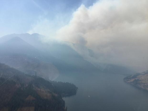
This is the view of the Wolverine Fire plume today from space. Much of the smoke is staying on Lake Chelan and drifting down lake to Chelan and Manson. Some of the smoke that is going higher in the atmosphere is being transported to the east towards the Methow Valley although monitors in Winthrop and Twisp do not show impaired air, at least not at the moment. Although the series of photos below, taken from the top of the Loup Loup ski area looking SW, show smoke moving through and thickening this afternoon. It's likely that some of this smoke will come down to the surface later this afternoon and evening.


Camera Location and View


7/31/2015 Wolverine Fire smoke in the Lake Chelan area
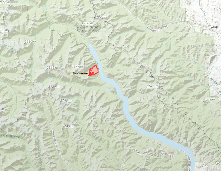
The Wolverine fire has seen increased activity with the return of warmer weather and is causing smoke impacts in the local area. Heavy smoke in areas near the fire, such as Lucerne, Holden, and Stehekin, is expected. Although smoke also likes to settle on the lake, especially at night and in the early morning, so will drift down lake towards Manson and Chelan.
See the table at the end of this post for a technique to estimate air quality conditions in remote areas when you are not near a monitor.
More on the Wolverine fire including evacuation notices is available at the link: http://inciweb.nwcg.gov/incident/4354/


See the table at the end of this post for a technique to estimate air quality conditions in remote areas when you are not near a monitor.
More on the Wolverine fire including evacuation notices is available at the link: http://inciweb.nwcg.gov/incident/4354/
Wolverine Fire Location
Wolverine Fire Smoke Plume (taken 7/30/2015)
|
Since
wildfires often occur in remote areas, air monitoring equipment may not be
available. The following table provides a quick method to assess air quality
in your area. For more detailed information you can go to the following site:
http://www.deq.state.or.us/aq/burning/wildfires/visibility.htm
|
||||
|
Using the 5-3-1 Visibility
Index
|
||||
|
Distance you can see*
|
You are:
|
|
You have:
|
|
|
· An adult
· A teenager
· An older child
|
· Age 65 and over
· Pregnant
· A young child
|
OR
|
· Asthma
· Respiratory illness
· Lung or heart disease
|
|
|
5 miles
|
check visibility
|
minimize outdoor activity
|
||
|
3 miles
|
minimize outdoor activity
|
stay inside
|
||
|
1 miles
|
stay inside
|
stay inside
|
||
|
*No matter how far you can see, if you feel like you are having
health effects from smoke exposure, take extra care to stay inside or get to
an area with better air quality. You
should also see your doctor or other health professional as needed.
|
||||
Thursday, July 30, 2015
7/30/2015 Wildfire Smoke Forecast, north central WA
Looks like smoke will settle in the Methow Valley tonight, perhaps degrading air quality to the unhealthy range.
Light NW wind Friday AM should clear the air a bit, but the light SW and variable winds may allow smoke to build up again.
Pattern may repeat until a Tuesday evening when the long range forecast predict a cold front out of the NW…more to follow.
You can see the plume originating from the top of Lake Chelan. http://sat.wrh.noaa.gov/satellite/showsat.php?wfo=pqr&area=west&type=vis&size=1


Wednesday, July 22, 2015
7/22/2015 Blue Creek Fire sending smoke to Clarkston/Lewiston area
The most active fire in Washington - the Blue Creek fire east of Walla Walla - is sending smoke east/northeast towards Clarkston and into Idaho. Air quality impacts at the monitor in Clarkston have not exceeded Moderate so far.
More information on the Blue Creek fire is available at the links:
http://inciweb.nwcg.gov/incident/4401/
https://www.facebook.com/WallaWallaEM
http://www.co.walla-walla.wa.us/Departments/EMD/index.shtml

More information on the Blue Creek fire is available at the links:
http://inciweb.nwcg.gov/incident/4401/
https://www.facebook.com/WallaWallaEM
http://www.co.walla-walla.wa.us/Departments/EMD/index.shtml

Tuesday, July 21, 2015
7/21/2015 Air quality is good, but fires are still burning
Northwest Fire Potential Summary:
An upper trough will set up over the region for the next couple of days. This will increase fuel moistures over most of the
area as it ushers in cooler and moister air. However, breezy conditions are also expected to continue across eastern
Washington and north central Oregon. The trough will likely result in some showers and scattered wet variety
thunderstorms as well, primarily east of the Cascades.
New large fire potential is expected to remain low. Initial attack activity should also remain low but a few lightning ignitions are likely
east of the Cascades.
Activity Summary In the Northwest: Lightning in NE Washington with scattered light precipitation and a few strikes in NE Oregon. Heavy initial attack activity in NE Washington. 3 New large fires reported with minimal growth on existing large fires.
1. Blue Creek WA-WFS-000514. IMT3. 10 miles E of Walla Walla, WA. Start 7/20. Full Suppression. Timber/Grass. Cause: Unknown. 2,500 acres. 0% containment. Extreme fire behavior with long range spotting. Structures lost and more threatened. City of Walla Walla Watershed and Blue Wood Ski area threatened. IMT2, WA Team 1 (Ciraulo/Jennings) ordered. Inbriefing 7/21 at 1200.
Lead Agency: WA Fire Service
https://www.facebook.com/WallaWallaEM?fref=ts
2. I-90 WA-WFS-000607. IMT3. 7 miles SW of George, WA. Start 7/19. Full Suppression. Grass/Brush. Cause: Unknown. 900 acres. 0% containment. Active fire behavior with wind driven runs. Standing wheat crops, homes, transporation infrastructure threatened, intermittent Interstate 90 closures.
Lead Agency: WA Fire Service
3. Wildhorse WA-OWF-000498. IMT3. 4 miles SW of Oroville, WA. Start 7/20. Full Suppression. Tall grass/Brush. Cause: Lightning. 122 acres. 0% containment. Active fire behavior. 9 Mile Ranch subdivision, residences and outbuildings threatened.
Lead Agency: USDA Forest Service.
http://www.fs.usda.gov/okawen/
4. PC Complex WA-PCS-000165. 8 miles NW of Amboy, WA. Start 7/19. Full Suppression. Timber. Cause: Unknown. 100 acres (+30). Active fire behavior. Complex consists of 5 fires. IMT2. WA Team 5 (Leitch/Holloway) mobilizing to the incident. Previously reported as Colvin Creek. Limited information available.
Lead Agency: WA Dept. of Natural Resources
5. Newby Lake WA-OWF-000337. IMT1. PNW Team 3 (Lewis). 23 miles NW of Oroville, WA. Start 7/02. Confine/Full Suppression. Timber. Cause: Lightning. 5,065 acres (+0). 30% containment. Fire started in Canada and crossed the border This will be the final 209 for this incident. The Type 3 Team will continue to submit a 209 using the new fire name and number. Newby Lake Long Draw -WA-NES-000801. IMT1 closing out 7/21 at 1000 hrs.
Lead Agency: USDA Forest Service
http://inciweb.nwcg.gov/incident/4355/
http://www.fs.usda.gov/okawen/

Morning Brief
Date/Time Stamp: Tuesday, July 21, 2015 - 0700 hrs
Activity Summary In the Northwest: Lightning in NE Washington with scattered light precipitation and a few strikes in NE Oregon. Heavy initial attack activity in NE Washington. 3 New large fires reported with minimal growth on existing large fires.
1. Blue Creek WA-WFS-000514. IMT3. 10 miles E of Walla Walla, WA. Start 7/20. Full Suppression. Timber/Grass. Cause: Unknown. 2,500 acres. 0% containment. Extreme fire behavior with long range spotting. Structures lost and more threatened. City of Walla Walla Watershed and Blue Wood Ski area threatened. IMT2, WA Team 1 (Ciraulo/Jennings) ordered. Inbriefing 7/21 at 1200.
Lead Agency: WA Fire Service
https://www.facebook.com/WallaWallaEM?fref=ts
2. I-90 WA-WFS-000607. IMT3. 7 miles SW of George, WA. Start 7/19. Full Suppression. Grass/Brush. Cause: Unknown. 900 acres. 0% containment. Active fire behavior with wind driven runs. Standing wheat crops, homes, transporation infrastructure threatened, intermittent Interstate 90 closures.
Lead Agency: WA Fire Service
3. Wildhorse WA-OWF-000498. IMT3. 4 miles SW of Oroville, WA. Start 7/20. Full Suppression. Tall grass/Brush. Cause: Lightning. 122 acres. 0% containment. Active fire behavior. 9 Mile Ranch subdivision, residences and outbuildings threatened.
Lead Agency: USDA Forest Service.
http://www.fs.usda.gov/okawen/
4. PC Complex WA-PCS-000165. 8 miles NW of Amboy, WA. Start 7/19. Full Suppression. Timber. Cause: Unknown. 100 acres (+30). Active fire behavior. Complex consists of 5 fires. IMT2. WA Team 5 (Leitch/Holloway) mobilizing to the incident. Previously reported as Colvin Creek. Limited information available.
Lead Agency: WA Dept. of Natural Resources
5. Newby Lake WA-OWF-000337. IMT1. PNW Team 3 (Lewis). 23 miles NW of Oroville, WA. Start 7/02. Confine/Full Suppression. Timber. Cause: Lightning. 5,065 acres (+0). 30% containment. Fire started in Canada and crossed the border This will be the final 209 for this incident. The Type 3 Team will continue to submit a 209 using the new fire name and number. Newby Lake Long Draw -WA-NES-000801. IMT1 closing out 7/21 at 1000 hrs.
Lead Agency: USDA Forest Service
http://inciweb.nwcg.gov/incident/4355/
http://www.fs.usda.gov/okawen/

Monday, July 20, 2015
Washington Wildfire Outlook - 20 - 24 July 2015
Cooler temperatures and higher humidities are helping to slow wildfire
growth in Washington and decreasing the smoke from surrounding
contributing areas. Although a series of troughs will move through the
Northwest this week, the potential for lightning looks low and there
should be few, if any, new starts.
However, we're not finished with the wildfire season yet. The three month
outlook (August, September, October) from the climate prediction center
has a higher probability of below normal precipitation and above normal
temperatures.
Expect a brief update on Friday the 24th to cover next weekend--I expect
it to be a copy of this outlook.
Clint Bowman
Air Quality Modeler
Department of Ecology
Friday, July 17, 2015
Washington Wildfire Outlook - 18 - 20 July 2015 (fwd)
See any smoke?
<http://lance-modis.eosdis.nasa.gov/cgi-bin/imagery/single.cgi?image=crefl1_143.A2015198191000-2015198191500.250m.jpg>
Nope! Neither do I.
A generally clear day over Washington, northern Oregon, and southwestern
British Columbia. Although there are numerous fires across southern British
Columbia, they are not emitting sufficient smoke today to be obvious. Air
quality at Washington PM2.5 monitors is good.
However, the forecast is for hot, dry weather which will likely increase fire
activity and produce more smoke. Although winds over the weekend will
increase, especially over southern British Columbia, they generally will be
westerly to southwesterly and should keep any smoke from coming south into
Whatcom or Okanogen counties.
Clint Bowman
Air Quality Modeler
Department of Ecology
Thursday, July 16, 2015
7/16/2015 Fire/Smoke Updates
The recent change in weather has decreased wildfire activity in the state and improved air quality. Below is a summary of the current fire situation for Washington and Oregon:
The NW is now officially at Preparedness Level 2, as is the nation. Initial Attack activity was as expected in Oregon with 19 fires for a total of 1 acre.
Washington was a little ornery with 6 fires for 2,009 acres. All but 9 of those
acres came from the Outlaw Draw Fire, a wind-driven grass fire SE of
Chelan. The fire was active and moving, demanding retardant drops until
the planes were grounded for the night. Breezy conditions are expected to increase in E WA and NE OR over the
next 48 hours, so there will likely be more fast moving grass fires. The
timber is still showing indices that will make large fire growth difficult.
The Newby Lake Fire grew by about 9 acres since the
last IR flight and now sits at 5,074 acres with 20% containment. On the north
end, two shot crews will continue working with Canadians today as they turn the
corner on the N side and start coming down the E flank. BC Forestry has agreed
to do the line rehab when it is needed, so the shot crews will be coming back
to the US at end of shift today. Last night, it snowed in their spike camp. On
the S and E flanks, crews are using Palm IR to look for heat sources around the
perimeter and going direct where it is safe to do so. There may be a need for
burnouts along portions of the S and E flanks. Those options will be assessed
today and if the decision is made, preparations will start quickly for a
possible Saturday burn window.
The Mt. Adams Complex is heavily into mop-up and
backhaul. The Type 2 IMT expects to meet turnback standards by end of
shift tomorrow. The closeout with the Forest is at 1400 on Friday and the
transition will occur at 0600 on Saturday.
The Douglas County Complex is now officially at 100%
containment, and Wolverine
is still being monitored. The Blankenship Fire in the Alpine Lakes
Wilderness on the Okanagon-Wenatchee NF is still quite small and will receive
occasional mentions based on activity.
Northwest Fire Potential Summary:
Dry and breezy conditions will develop by later today across Eastern Washington and to a lesser extent Eastern Oregon.
This is in response to an upper trough swinging through the region from the north. As this system drops southward Friday
and Saturday it could kick off of a few showers or thunderstorms but Initial Attack activity should remain rather subdued and not
expected to present a problem for Initial Attack resource capability.
Monday, July 13, 2015
Wildfire smoke forecast 13- 15 July 2015
As expected, southwesterly flow over the weekend helped flush out smoke from most areas of the state. Air quality has remained good at most locations statewide since Saturday evening, though a few areas took a little longer to scour out.
Southwest winds will continue through Wednesday before turning northwest on Thursday. There is a risk of lightning in the far southeastern part of the state today, followed by strong winds through the mountain gaps and Columbia Basin.
Washington is likely to see good air quality at most locations through the work week, though areas close to wildfires could occasionally see moderate air. But lightning and strong winds may cause new fires and pose problems for firefighting efforts, so we’re not out of the woods yet.
~*~*~*~*~*~*~*~*~*~*~*~*~*~*~*~*~*~
Ranil Dhammapala, PhD
Air Quality Program
Washington Department of Ecology
Email: ranil.dhammapala@ecy.wa.gov
~*~*~*~*~*~*~*~*~*~*~*~*~*~*~*~*~*~
Friday, July 10, 2015
Washington Smoke Forecast for 11 – 13 July 2015
The precipitation predicted for this weekend will do little to suppress
the wildfires burning in Washington or Oregon. There may be some decrease
in wildfire smoke production in Idaho and British Columbia beginning
Saturday afternoon. Rain expected along the Oregon Cascades and on across
northeastern Oregon and into the southern Idaho Panhandle on Sunday should
reduce smoke production from fires located in those regions. Rain will
increase in the Cascades of Oregon and Washington as well as the Olympics
of Washington on Monday. This rain should help suppress the small fires on
Mt Adams and reduce the possibility of smoke continuing to affect the
areas just east of the Washington Cascades.
The biggest relief from smoke in Washington this weekend will come from
the south to southwest winds that, beginning on Saturday, will scrub smoke
from most locations in Washington.
Clint Bowman
Air Quality Modeler
Department of Ecology
7/10/2015 Westside clearing and one very cool satellite photo
Changing weather brought cooler temperatures and winds to western Washington overnight resulting in significant clearing of the lingering BC wildfire smoke and improvements in air quality. All sites, with the exception of Neah Bay, show Good air quality. East of the Cascades we see numerous sites in central Washington continue to experience air quality in the Unhealthy-for-Sensitive-Groups (orange) range. The far eastern part of the state is also improved and shows a mix of Good and Moderate air quality this morning. (View the live image of monitoring site status here: https://fortress.wa.gov/ecy/enviwa/Default.htm)

And it's not over Washington but the National Weather Service office in Glasgow Mt. posted a very interesting satellite photo this morning of smoke swirls over Canada, Montana, and North Dakota. The image is of combined smoke from the BC fires and other fires in Saskatchewan.
Here's a link to their Facebook page for more info.: https://www.facebook.com/NWSGlasgow

Thursday, July 9, 2015
7/9/2015 Widespread haze and smoke continues from BC wildfires
Smoke from the British Columbia wildfires continues to leak down into Washington causing widespread haze and moderate to unhealthy-for-sensitive-groups air quality conditions across most of the state. We have some wildfires in Washington also but they're not putting out nearly enough smoke to cause all this impairment. In fact it looks like the one fire we have with a somewhat significant plume - the Newby Lake fire located right along the Canadian border in the middle of the state - was sending smoke north into Canada at the time of this satellite photo.


Wednesday, July 8, 2015
Spokane Area: Wildfire Smoke Impacting Air Quality, Health Precautions Suggested
| ||||||||
|


7/8/2015 Generalized haze and one significant plume
The satellite view of Washington from this afternoon shows just one significant plume of smoke. It appears to be from the Newby Lake fire which started in Canada and has moved into the Pasayten wilderness and the Loomis State Forest. The latest report from the Newby Lake Incident is from yesterday but guessing from the size of the visible plume, it made a pretty good run today or at least hit some heavy pockets of fuels. More on Newby Lake: http://inciweb.nwcg.gov/incident/4355/

Much of the state is experiencing impaired air quality from the accumulation of smoke from the Washington fires but also the smoke that's coming our way from British Columbia. At least 20 state air quality monitors are registering Unhealthy for Sensitive Groups at the moment. (Orange dots on the map below.) Here's a link that will take you to the advice that goes along with the air quality warning levels: https://fortress.wa.gov/ecy/enviwa/App_AQI/AQI.en-US.pdf And in Spanish: https://fortress.wa.gov/ecy/publications/publications/0802022es.pdf


Much of the state is experiencing impaired air quality from the accumulation of smoke from the Washington fires but also the smoke that's coming our way from British Columbia. At least 20 state air quality monitors are registering Unhealthy for Sensitive Groups at the moment. (Orange dots on the map below.) Here's a link that will take you to the advice that goes along with the air quality warning levels: https://fortress.wa.gov/ecy/enviwa/App_AQI/AQI.en-US.pdf And in Spanish: https://fortress.wa.gov/ecy/publications/publications/0802022es.pdf

7/8/15 Smoky Haze with Some Relief . . . in Central Washington
Expect smoke and haze to continue through Thursday. North winds are pushing smoke down into to the Cascade Valleys and Basin. More Central Washington communities may see air quality in the unhealthy for sensitive groups and unhealthy ranges.
With high temperatures today
and Thursday, air quality may improve
slightly as smoke becomes aloft, returning some areas to moderate levels.
Starting Thursday night, a
strong cold front arrives out of the
Northwest with cooler temperatures and humidity. Initial
relief from the smoke before hazy conditions return due to lighter winds
and cooler temperatures.
Looking Ahead: Combination of Northwest fires producing
heavy smoke with humid air and lighter winds . . . smoke moves smoke down valleys
- we could have a smoky start to next week.
Subscribe to:
Posts (Atom)