Dry and unstable conditions over the Cascades are leading to increased smoke
The ridge of high pressure responsible for our warm and dry weekend is peaking in strength today, bring warm and dry conditions to much of the state. Over the active fires in the Cascades, unstable conditions have developed which leads to much more active burn periods in the afternoon hours. Coupled with light winds and cool nights, smoke can easily get trapped in valleys and drainages on both sides of the Cascades.
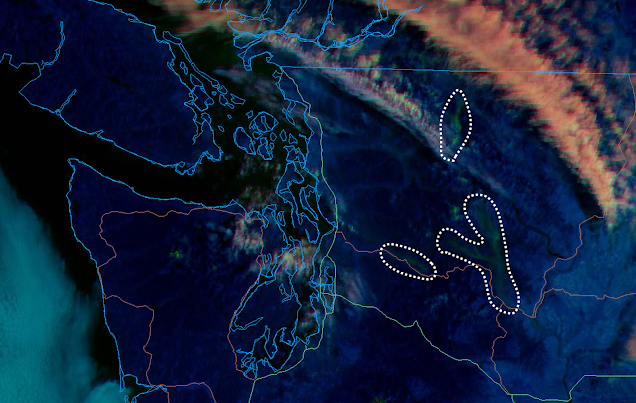
The image below depicts where smoke settled last night on fires in the central and north Cascades:
The ongoing fires in the Cascades are responding to the warm, dry, and unstable conditions today by burning quite actively this afternoon, producing more smoke than they have in at least two weeks. The National Weather Service has issued Red Flag Warnings for the Cascades above 2,000', where fuels are dry and conditions are right for fires to experience rapid growth.
The image below depicts where active fires are depositing smoke this afternoon:
Another ridge will take shape over Washington on Friday and will continue through the weekend, with weather conditions being very similar to what we saw this weekend. Smoke impacts will likely crop back up in that timeframe, but with the wetting rainfall, air quality degradation will be limited to areas closest to the active fires.


I have a question, do you have any idea why today there was such a difference between purple air and airnow? I do know their pros/cons differences/similarities but today they're further off than I've seen them. It makes me unsure how to proceed given asthma. Airnow for large chunks of the day was in the moderate zone while purple air was in the almost very unhealthy range. Usually they aren't this far apart :-D
ReplyDeleteWithout knowing which location, the duration, or which tool you are using to compare, it's tough to say. If it was one particular low-cost sensor, it could be out of calibration or have localized effects. If it was a group of sensors, it may have been particularly fresh smoke with small particles. Low-cost sensors are particle counters and do not measure mass concentration. There could have also differences because of 10-min updates from purple air and hourly averages from the the official monitoring network. If you compare the hourly timelines rather than just the color map, you may find more clues.
DeleteWhen you are looking at the Purple Air map, make sure you have enabled either the LRAPA or the EPA correction. There is a white bar in the upper left hand corner of the map. Click on that bar and in the second drop down menu choose either the LRAPA or EPA correction. Both are decent for our region. The main map above shows EPA corrected Purple Air sensors (squares) and the government monitors (circles). You can also view this map at https://fire.airnow.gov/
DeleteHere's hoping the rain can help douse the Bolt Creek fire.
ReplyDelete