Friday, July 21, 2023

High Altitude Smoke and Eastside Fire Weather

Close observers of the Fire and Smoke Map (airnow.gov) over the last few days may have noticed the persistent smoke plume overlaying our region, as seen from the Thursday 7/20 afternoon image below.


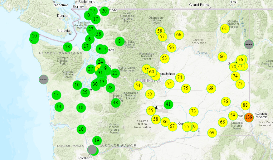
Very close observers may have wondered: “If the skies of Washington State have been dimmed by smoke from wildfires in Oregon and Canada for the last few days, how is it that our Air Quality index has mostly remained GOOD?”

The answer is that the smoke plume from these out of region fires has remained aloft at or above 10k feet; when smoke is present at that altitude but not at ground level, it can register on satellite imagery, but not on air quality monitors and sensors on the ground.

Within the state, fires on Joint Base Lewis-McChord have contributed near surface smoke to the south Puget Sound beginning on Wednesday 7/19. At least one these fires is burning in the Artillery Impact Area and is therefore not subject to full suppression tactics. Expect this fire to continue to produce mild-moderate smoke impacts locally until it burns itself out.

NOAA HRRR Near Surface Smoke: 7/20 @ 3:15pm

Other smaller fires did occur on both sides of the Cascades this week, but were quickly suppressed, and did not have lasting impacts on local air quality.

Moving into the weekend, the National Weather Service has identified elevated fire risk for the eastside of the state from Friday through Monday. By observing fire bans, fully extinguishing recreational fires where they are allowed, and traveling responsibly you are making a positive contribution to Washington State’s public health and safety.

Enjoy the weekend!

Wednesday, July 19, 2023

Industrial Fire in Longview Causing Smoke Impacts in the Vancouver/Portland Area

Residents in the Vancouver/Portland area woke up to unhealthy air quality levels this morning. Air quality deteriorated overnight due to transported smoke from an industrial fire at Nippon Dynawave Packaging in Longview that started yesterday evening.

    Source: EPA Fire and Smoke Map, 9am


The smoke arrived in the Vancouver area around 8pm last night--the hourly PM2.5 timeseries below shows the smoke transport down the Columbia River in the evening hours and impacting the air quality monitors in Vancouver; the Longview monitor is upwind of the fire location so did not observe elevated PM2.5 concentrations. 


We are starting to see decreases in PM2.5 concentrations as mixing and ventilation increases this morning, and clearing should continue throughout the day. However, smoke impacts in Vancouver will likely persist through tomorrow as the fire continues to smolder and a marine layer traps any smoke near the surface. 

Also contributing to smoke in the area is a fire at an abandoned K-Mart building in northeast Portland.

The Southwest Clean Air Agency has issued a Air Pollution Advisory for Clark and Cowlitz Counties today through Friday, July 21. We'll continue to monitor the situation and update the blog as needed.

Friday, July 14, 2023

Weekend Fire Weather Watch and Heat Warning

The National Weather Service has issued a Heat Warning and Fire Weather Watch for Central and Eastern WA, with temperatures over 100 degrees expected in the Tri-Cities and other nearby areas.  The hottest temperatures will be on Sunday in the Columbia Basin, while winds become gusty.  A dry cold front will sweep through on Monday delivering strong winds with the potential to spread any new fires.  We will need to take extra care to recreate responsibly this weekend by observing fire bans, and fully extinguishing recreational fires where they are allowed. Stay hydrated and prepare for high temps! 


There aren't any large fires in Washington right now but there are some small recent fires near the southern border of our state.  The Knight Road fire in Klickitat County has subsided and the Gordon Butte Fire along Fulton Ridge in Oregon should be manageable.

We have seen occasional moderate air quality from Canadian wildfires skirting across the northeast border of our state, and this will likely continue into the future.  However, we are getting really good wind directions to avoid Canadian smoke and this should continue for the near-term.  We expect Good air quality in Washington through the weekend, except for some moderate local impacts from any new fires that occur.  The fires in Canada are getting really bad though, so it will be an issue for us in the weeks to come.  

GOES Image of Canadian Wildfire Smoke - July 14 @ 8 a.m. PDT


Wednesday, July 5, 2023

Fireworks, wildfire smoke, and hot weather

The combination of good weather (a high pressure system), wildfire smoke from British Columbia, and fireworks led to very high air pollution last night in the Puget Sound area.  This was particularly true in Pierce County where air quality was in the Very Unhealthy range earlier this morning.  Thankfully air quality has greatly improved and most areas are Moderate.


Air quality as of 12pm 7/5/2023


With another hot day today we should see good vertical mixing – when the air near the ground heats up and rises, bringing smoke with it.  This will dilute the smoke and continue to improve air quality.

The majority of the pollution we saw last night was due to fireworks.  The wildfire smoke from British Columbia, which arrived earlier in the day on July 4th, only pushed us from Good to Moderate.  We don’t expect more of that smoke in the near future, though the fires are still burning and the possibility of smoke later on remains.

Given that, we may see another (smaller) pollution spike tonight depending on how many fireworks are left over.

Also, there is a wildfire near Shelton, the McEwan fire, that started yesterday afternoon and has burned around 250 acres as of last count.  Crews are working to create fire lines to prevent the fire from spreading.  Air quality in Shelton is currently at Unhealthy For Sensitive Groups and smoke impacts are expected to persist for the time being.  So far we expect impacts to be local, but models show that some smoke could reach Pierce County overnight.

Sensors in Skamania county along the Columbia river are showing USG smoke impacts from the Tunnel Five fire.

We will continue to monitor the situation and update as needed.


Monday, July 3, 2023

Tunnel Five Fire near White Salmon and 4th of July Update

Just a couple miles west of White Salmon, the Tunnel Five fire is burning actively in timber and brush, causing local smoke impacts in Skamania and Klickitat counties along the Columbia river.  Evacuations and road closures are in effect while crews work on containing the fire.  Currently the fire has burned over 500 acres in hot/dry conditions, and winds are expected to send smoke around the Columbia river gorge in that area for the next few days.  White Salmon is currently showing unhealthy air on sensors, with moderate smoke making its way to Dallesport.  Tuesday and Wednesday will have a wind shift, with local smoke impacts expected in Carson, Stevenson, and North Bonneville.

Image: Smoke from the Tunnel Five fire on July 2, 2023.  Source: yahoo.com

Hot and dry weather is expected through this week with fire danger expected to peak on Wednesday/Thursday. Fire potential is elevated on the 4th of July due to the combination of rising fire danger, dry weather, and potential extra ignitions. The National Weather Service currently has a Red Flag Warning for Central WA and SouthWest WA.

Meanwhile, we expect some moderate smoke to impact parts of WA on Tuesday/Wednesday from the BC fires.  This will likely cause hazy conditions and some minor smoke impacts, at first across the northern counties of the state (e.g. Clallam, Whatcom, Okanogan, etc.) and potentially lingering across the state into Thursday.

Enjoy your mid-week Holiday!

Friday, June 30, 2023

Statewide smoke forecast for the weekend and beyond

While there are a few small fires in Central Washington, air quality across Washington State is GOOD (we're thinking of our friends in the midwest and on the east coast that are currently dealing with poor air quality). However, a building high pressure system will result in hot and dry temperatures through the weekend.

The National Weather Service issued a Fire Weather Watch for portions of Central Washington on Saturday.


Please keep in mind that fireworks not only contribute to smoke but also are responsible for starting new fires. Fires can start and spread much more easily in hot and dry conditions. Please exercise extreme caution if igniting fireworks. If recreating, check local fire restrictions and consider if a campfire is necessary. 

Based on the hot and dry weather, some areas may observe Moderate to Unhealthy for Sensitive Groups air quality intermittently through the weekend and holiday. It's also likely that local smoke impacts from firework displays and usage will linger into the morning of July 5th. 

We're also keeping an eye on the wildfires burning in Alberta and British Columbia--shifting conditions to winds from the north could lead to smoke impacts in Washington State next week. At this time it's uncertain how much of that transported smoke will reach the surface and how much will stay above us in the atmosphere. A reminder that the latest air quality conditions and 5 day smoke forecast are shown in the map at the top of this page, and we'll update the blog as needed.

Have a safe and happy 4th of July!


Thursday, June 15, 2023

Minor Smoke Impacts Today; Clearing for Weekend

Smoke from British Columbia is filtering southward into Washington


The 1.2 million acre Donnie Creek Fire in northeast British Columbia is primarily responsible for the smoke impacts we are seeing this morning across eastern Washington. The smoke is being driven southward by the low pressure system that brought strong westerly winds to Washington earlier this week, and is currently departing the state to the northeast. Due to the origin location of the smoke and the current prevailing wind pattern, smoke is expected to remain east of the Cascade crest in Washington. 


Gusty westerly winds return Friday, clearing smoke


In the wake of the low pressure system, Washington will experience a much calmer day of weather for Thursday, with weaker winds and slightly sunnier skies. The pattern will turn cloudier and windier again by midday Friday as another low pressure system moves toward the Pacific coast from the west. Strong westerly winds will again develop for Friday and are likely to continue through the weekend. These winds will clear out the current smoke through the night Thursday, and we should see much improved AQI's across the state for Friday and the weekend. 

There were several grass fires in south and central Washington that ignited on Tuesday and Wednesday under the dry and very windy conditions, and fire danger will again be elevated for Friday and Saturday. The smoke from these grass fires did not cause any air quality issues due to the strong winds and excellent vertical mixing quickly lifting the smoke above ground level and dispersing it in the wind. Fire danger for Friday and Saturday will not be as high as it was on Tuesday, but any new fire starts in fine, grassy fuels will be capable of quick spread, though their smoke impacts will be minimal. 

This week is Smoke Ready Week in Washington! Learn more about how wildfire smoke affects your health and steps you can take to reduce your exposure here: Smoke Ready WA


Matthew Dehr, Wildfire Meteorologist 
Washington DNR 

Monday, June 12, 2023

June 12-16 is #SmokeReady Week

It appears summer has arrived early in the Pacific Northwest so now is the ideal time to prepare for wildfire smoke season. 

Wildfire smoke not only affects your outdoor plans, but it can make it hard to breathe, and cause or worsen existing health problems.

Every year federal, state, and local agencies and Tribes across the region get #SmokeReady to bring you the most current information on how wildfire smoke may impact your summer plans and health through this blog. 

Read more about wildfire prevention, where to find burn ban information, how to monitor air quality, and get smoke forecasts on the Washington Dept. of Ecology’s website or read their blog available in English and Spanish:

And then take some time to review the Washington Dept. of Health’s guidance on how to protect yourself and your family’s health from wildfire smoke.

Each day this week has a different #SmokeReady theme:
Monday: What's in smoke?
Tuesday: Stay informed about air quality
Wednesday: Smoke and your health
Thursday: Strategies to minimize smoke exposure
Friday: Preventing smoke

Let's get #SmokeReadyTogether and have a safe and enjoyable summer!


Friday, May 19, 2023

When will the smoke in Central and Eastern WA clear out?

Smoke from the Canadian wildfires continues to impact Central and Eastern Washington, with monitors observing Air Quality Index values corresponding to Moderate and Unhealthy for Sensitive Group levels.


Due to the residual smoke lingering in the region, the Air Quality Alert has been expanded to include all Central and Eastern Washington counties. The Air Quality Alert will expire tomorrow morning at 10am.

Some haze and smoke will persist throughout today, and temperatures will get hot, but air quality should slowly improve thanks to a push from southwest winds. We'll return to our normal May air quality conditions by the end of the weekend with the arrival of a cold front.  The latest FireWork model forecast animation below shows the smoke plume moving away from Washington State:


Thursday, May 18, 2023

Welcome to the 2023 Wildfire Smoke Season

Wildfire season is starting a bit earlier than expected due to smoke from large fires in central Alberta. While the Canadian fires have been burning for a couple weeks, shifting weather patterns to northeasterly winds brought the smoke to Washington State. This morning's GOES-WEST satellite image shows the plume of smoke across the state. Luckily, that plume of smoke is mostly staying above us--it's too high in the atmosphere to mix down to the surface. 


However, we are seeing some ground-level smoke impacts in the north central and eastern parts of the state, with monitors observing hourly PM2.5 concentrations corresponding to an Air Quality Index of Moderate:

        Source: EPA Fire and smoke map, 8:45am


An Air Quality Alert has been called for the following counties and expires Saturday, May 20 at 10am: Okanogan, Ferry, Stevens, Pend Oreille, Lincoln, Spokane, Adams, and Whitman. PM2.5 levels may reach Unhealthy for Sensitive Group levels in these counties. While today will be hazy in these areas, relief from the smoke will come later in the day with the arrival of southwest winds. If conditions improve, the Air Quality Alerts will be lifted before Saturday.

As far as the rest of the state, the smoke is high enough in the atmosphere and very unlikely to mix down to the surface and impact the air we breathe. Take a look at this image of the smoke aloft from Puget Sound Clean Air Agency's ceilometer in Marysville, where we can see the smoke (dark grey bands) present at around 3-5 km above ground:


Smoke in May caught us all by surprise, but it's a good reminder to be prepared for the upcoming wildfire smoke season. We'll update this blog as conditions change, and be sure to visit the Health Information tab on this page for tips on how to protect yourself from wildfire smoke.