Purple air sensors near Lake Cushman currently report hazardous air quality due to the Bear Gulch Fire. Vertical mixing and dispersion should improve air quality in the area throughout the day. That said, warm and dry conditions could increase fire activity and cause air quality to degrade later this evening. The fire is burning in steep terrain, causing challenges for firefighting efforts. Firefighting crews are currently protecting the Staircase Area and other nearby park structures. The Bear Gulch Fire will likely burn for several weeks until the area receives significant precipitation, causing intermittent smoke impacts for the foreseeable future.
Nearby fires are also contributing smoke in the Lake Cushman/Hoodsport Area. The Hamma Fire (about 2.5 miles northwest of Eldon) began on July 27th and the Browns Creek Fire south of Lake Cushman started yesterday afternoon and has burned about 12 acres.
 |
| Smoke plumes from the Bear Gulch and Hamma Fires. Source: Inciweb. |
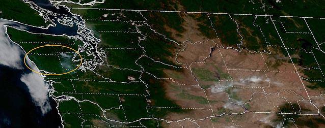
The South Huckleberry Fire, west of Lake Quinault, was reported this morning at about 15 acres with a smoke plume visible on satellite imagery.
 |
| Highlighted circle shows smoke plumes from the South Huckleberry, Hamma, Browns Creek, and Bear Gulch Fires. GOES-WEST 29 JUL 2025 17:16Z |
Communities near these active fires will observe the greatest smoke impacts overnight and into the morning hours before smoke disperses during the day. Kitsap County may also experience periods of moderate air quality. Outside of these areas, surface air quality should continue to be mostly good in Western Washington, although upper-level haze will be visible throughout the region.
As for the rest of the state, recent air quality has generally been good throughout Central and Eastern WA. Containment has increased for the larger fires; the Burdoin, Hope, and Lake Spokane fires have not grown significantly and continue to show little activity. The Pomas Fire continues to burn near Entiat with minimal smoke impacts.
Continued hot and dry conditions statewide could increase smoke production from active fires in coming days. Thunderstorms Wednesday through Friday bring the potential for new fire starts with the greatest risk Wednesday with dry thunderstorms over the Cascades.
Update: July 30, 3:30 PM Smoke from the Bear Gulch Fire is impacting most of Mason County and causing unhealthy air quality throughout the region. This was unexpected based on forecast winds, but when smoke is thick enough it can stabilize the atmosphere and change the local weather. We don't yet know how long the smoke will last or how far from the source it will spread. All residents in Mason County should limit their outdoor exposure this evening. Residents in North Thurston and south Kitsap may also see some smoke impacts. We'll keep you updated as we get more information.
I can already smell it in Olympia and smelled it last night too. Yet apparently it's still classed aa "good" by this blog as well as air gov. I tend to believe that if the human can smell it, it's probably automatically not really "good" but that's just me. Fingers crossed that a cold weather and rain front comes in soon for all areas, but I know it ain't likely. Time to hook up the air purifier over here.
ReplyDeleteThe good air quality classification is based on both government owned and publicly owned air quality monitors and sensors, which have all been generally green (below an AQI of 50 and a PM2.5 concentration of 9 µg m-3) in the Olympia area. Several Olympia sensors did peak into low moderate values around 10pm last night (July 29) and you may have smelled smoke around that time. Please see our blog post from June 13th for more information regarding the NOWCast AQI and why it doesn't always line up with instantaneous observation.
DeleteIt was close to 8 p.m. or so, but close enough. Not quite so bad this morning, as though it was aloft in the earlier part of the day and then settled. Detect it a little more faintly today, can definitely see it up in the trees as a misty shroud. Very faint, I mean I know it could be a lot worse. I'll check out that other post later. Thank you so much for the work you and your team do every day. The community appreciates you, I certainly do.
DeleteWhen a region is shown in any AQ color on the map, is the AQ determined using vertically integrated or surface smoke models? If surface, what does that mean if hiking in the mountains? A trail is a surface, but if hiking at 6,000 feet, is the air one breathes “aloft” and not technically “surface” in meteorological terms? What service should I use if I'm trying to decide whether to move forward with a hike, as I don't want to breathe any smoke. Thanks.
ReplyDeleteThe monitors and forecast are all based on surface smoke concentrations. You're right--if you're hiking at 6,000 ft the air you're breathing may not be represented by surface concentrations. Some air quality monitors are at higher elevations (i.e., at Mt. Rainier's Jackson Visitors Center). The high resolution rapid refresh (HRRR) smoke model forecasts smoke at various heights: https://rapidrefresh.noaa.gov/hrrr/HRRRsmoke/Welcome.cgi?dsKey=hrrr_ncep_smoke_jet&domain=t1 (loop 1000 ft AGL smoke, 6000 ft AGL smoke). The 48 our forecast is updated four times a day.
Delete