Monday, July 21, 2025

A Short but Welcome Reprieve from Hot, Dry Conditions


Fire Updates

While the weekend remained hot and windy, two notable wildfires ignited: the Lake Spokane Fire (located Northwest of Spokane) and the Burdoin Fire (located about 2.5 miles east of White Salmon, WA, along the Columbia River).

View of Burdoin Fire from Oregon. Image courtesy Burdoin Fire Facebook. 

The Lake Spokane Fire is currently burning 1,751 acres and is 1% contained. The Burdoin Fire has rapidly expanded to 10,730 acres since its ignition Friday afternoon, fueled by strong winds gusting through the Columbia River Gorge on Friday and Saturday. It remains at 0% containment.

View of Lake Spokane Fire. Image courtesy of Snohomish FD4.

Air Quality Overview

Air quality is currently GOOD across Western Washington, thanks to a low-pressure system that moved in over the weekend, clearing out much of the hazy air. In Eastern Washington, MODERATE air quality has been reported across the Columbia Basin due to smoke from the Burdoin fire. Areas near the Lake Spokane fire have experienced air quality rising to UNHEALTHY just this afternoon. If you're in areas with elevated smoke levels, it's best to stay indoors, limit strenuous outdoor activity, and keep windows closed to reduce exposure.

Smoke from Burdoin Fire as seen from Columbia River. Image courtesy Burdoin Fire Facebook.

Weather Outlook

Today and tomorrow bring a short reprieve from critical fire weather as cooler temperatures settle in. The low-pressure system will move slowly across the state, bringing cooler conditions, scattered rain showers, and low winds, a welcome break in what has been a hot, active fire season. Starting Wednesday, Eastern Washington will return to very warm and dry conditions. Winds will increase by Thursday, setting up a period of hot, dry, and windy weather, ideal conditions for new wildfire starts. Smoke impacts could increase by the end of the week, so keep an eye on local air quality conditions.

Fire Containment Update

There is some good news: the Hope and Pomas Fires are now producing significantly less smoke, and the Western Pines Fire is 100% contained!

As always, check the air quality map at the top of this page for the most up-to-date conditions and stay smoke-aware.

Friday, July 18, 2025

Onshore Winds and Cooler Temps this Weekend

Fire activity has continued across Washington this week. On the west side of the state, the Bear Gulch Fire continues to burn near the Staircase entrance to Olympic National Park. The fire is 562 acres and 19% contained. Hot and dry weather led to increased fire activity this week, but cooler weather is on the way (more on that later).

The Bear Gulch Fire burning in steep terrain above Lake Cushman on Wednesday, July 16.

Fires also continue east of the Cascades. The Pomas Fire is 3521 acres, burning very far up the Entiat River Valley - also in steep, rugged terrain.

The Hope Fire, north of Kettle Falls, is 7414 acres and 25% contained. 

View of the Hope Fire from Churchill Mountain, Thursday July 17, 2025. Credit: Ryan Sullivan, NW Team 8.

The two other large fires in the state are the Greenacres Fire and Western Pines Fire, but both are now 95% contained and producing minimal to no smoke. 

With the hot weather and increased fire activity this week, there have been reports of minor smoke and haze across the state. Luckily, surface air quality has generally remained in the GOOD to MODERATE category. Additionally, a frontal system is moving across the state Friday afternoon, helping to further clear out smoke/haze for most areas. 

This frontal system is also producing high fire danger across eastern Washington. A Red Flag Warning is in place across the Columbia Basin due to a combination of high winds, hot temperatures, and dry air.


After this latest peak in fire danger, temperatures will continue to cool down statewide Saturday into Sunday and fire danger will gradually wane. As a result, active fires will likely produce less smoke going forward into early next week. Still, minor to moderate smoke impacts may continue for communities in close proximity to any new or existing fires.

As a reminder, you can always stay updated on current air quality by viewing the map at the top of the blog site. Have a great weekend!

Monday, July 14, 2025

Canadian smoke and critical fire weather

Smoke from the Placer Creek Fire in Southern BC is impacting communities in northeastern Washington. The fire began over the weekend and has quickly grown to 6400 acres. This morning's satellite image shows the smoke plume moving southeast.

GOES-WEST 14 Jul 2025 15:11Z

Smoke is also visible west of Tonasket:

Smoke visible at Aeneas Mountain west of Tonasket. Image courtesy: DNR/Pano

Smoke from the fire will continue to impact northeastern Washington until shifting winds this afternoon push the smoke south into the Okanogan Valley.

Smoke from the Hope and Western Pines Fires in northeastern WA continue to impact nearby communities. Firefighting efforts on both fires continue, but hot, dry, and windy conditions will challenge efforts and increase fire activity. Communities nearby to both fires should continue to expect intermittent smoke impacts. In general, most of Central and Eastern WA will observe moderate air quality over the next few days due to multiple fires in the region.

Critical Fire Weather Today

Extreme fire weather is expected this afternoon in Okanogan Valley; very strong winds (sustained winds 30-40 mph and gusts up to 50-60 mph) are forecasted for the area. The strong winds in addition to the hot and dry conditions will contribute to critical fire weather in the Okanogan Valley as well as the Columbian Basin. A Red Flag Warning has been issued for most of Eastern WA through Wednesday.

These strong north winds will transport Canadian smoke south into the Okanogan Valley. Any new fire starts will spread quickly and existing fires (including the Pomas Fire) will exhibit increased growth. 

Fire weather concerns will ease Thursday with the return of westerly winds that will also help scour out any areas of poor air quality.  


Western WA Smoke Impacts Tomorrow

Tomorrow winds from the northeast will push Canadian smoke into northwestern Washington (primarily eastern Whatcom, Skagit, and northern Snohomish counties). Most of the smoke will likely stay above us in the atmosphere but a fraction may mix down to the surface tomorrow afternoon leading to moderate air quality at worst. Haze may be noticeable across western Washington before westerly winds return on Thursday.

Thursday, July 10, 2025

Statewide smoke update

There are a number of fires across the state causing mostly localized smoke impacts. Moving west to east:

The Bear Gulch Fire along Lake Cushman has increased to 415 acres. Smoke impacts have been minimal thanks to recent cooler weather, but communities closest to the fire should expect intermittent periods of smoke. Authorities are asking people to avoid the north end of Lake Cushman and many recreation sites are closed.

The Toonerville Fire in Belfair (currently 85 acres) has also caused minor smoke impacts to the immediate area. Evacuations are in place; more information can be found from the North Mason Regional Fire Authority.

The Pomas Fire northwest of Entiat continues to grow (currently 3,330 acres) and exhibit active fire behavior. Smoke impacts will continue to be concentrated in the Entiat River Valley.

In Lincoln County, the Western Pines Fire (10 miles north of Davenport) began yesterday and has grown to almost 4,000 acres. Smoke from the fire is currently impacting the Wellpinit area. Smoke will disperse to the east this afternoon. Tonight and into tomorrow morning winds will push smoke to the south of the fire, causing periods of Unhealthy for Sensitive Groups air quality in the Davenport area.

Located about 15 miles north of Kettle Falls, the Hope Fire began on the afternoon of July 8 and has quickly grown to 6,700 acres. The fire is burning mainly in grass and shrubs, and smoke impacts have largely been concentrated in and to the north of Kettle Falls. Local smoke impacts will continue with periods of Unhealthy for Sensitive Groups and potentially Unhealthy air quality closest to the fire. Communities to the south of the fire (including Colville) will likely observe smoke impacts tonight and into tomorrow morning.

Cooler temperatures continue today, but breezy winds may spread smoke. Warm, dry, and windy conditions return this weekend leading to increasing smoke from active fires and rapid spread of any new fire starts. Keep an eye on current and forecasted air quality at the map at the top of this page and we'll update as necessary.

Western Pines Fire in north Lincoln County. Source: Watch Duty.


Tuesday, July 8, 2025

Bear Gulch Fire burns along Lake Cushman, Pomas Fire sees significant growth

Bear Gulch Fire

Folks along the southeastern Olympic Peninsula and around the Puget Sound might've noticed a layer of haze Tuesday morning. 

The Bear Gulch Fire started Sunday evening in the Olympic National Forest along the northern shore of Lake Cushman and produced an impressive smoke plume Monday afternoon and evening.

Warm, dry weather fueled the fire on Monday and has burned approximately 200 acres, per the Olympic National Forest

Air quality near the LCMC Park on the east shore of Lake Cushman was UNHEALTHY Monday morning, with improvement to GOOD by Monday night. Air quality has since degraded and is back to UNHEALTHY conditions Tuesday morning.

Smoke from the Bear Gulch Fire from a camera in the southern Olympic Mountains. Image courtesy: DNR/Pano

Slightly higher relative humidity should limit fire growth on Tuesday but expect the fire to continue to produce smoke with the greatest impacts along Lake Cushman. Communities such as Hoodsport, Potlatch, and Skokomish may see periods of UNHEALTHY FOR SENSITIVE GROUPS, mainly in the morning hours.

For updates on the fire, follow the Olympic National Forest and the Mason County Sheriff's Office on Facebook.

Pomas Fire

Jumping over to the Cascades, the Pomas Fire continues to burn in the upper Entiat River valley. Monday was a very active day, with pyrocumulus clouds observed multiple times in the afternoon and evening, and an impressive smoke plume visible on satellite imagery.
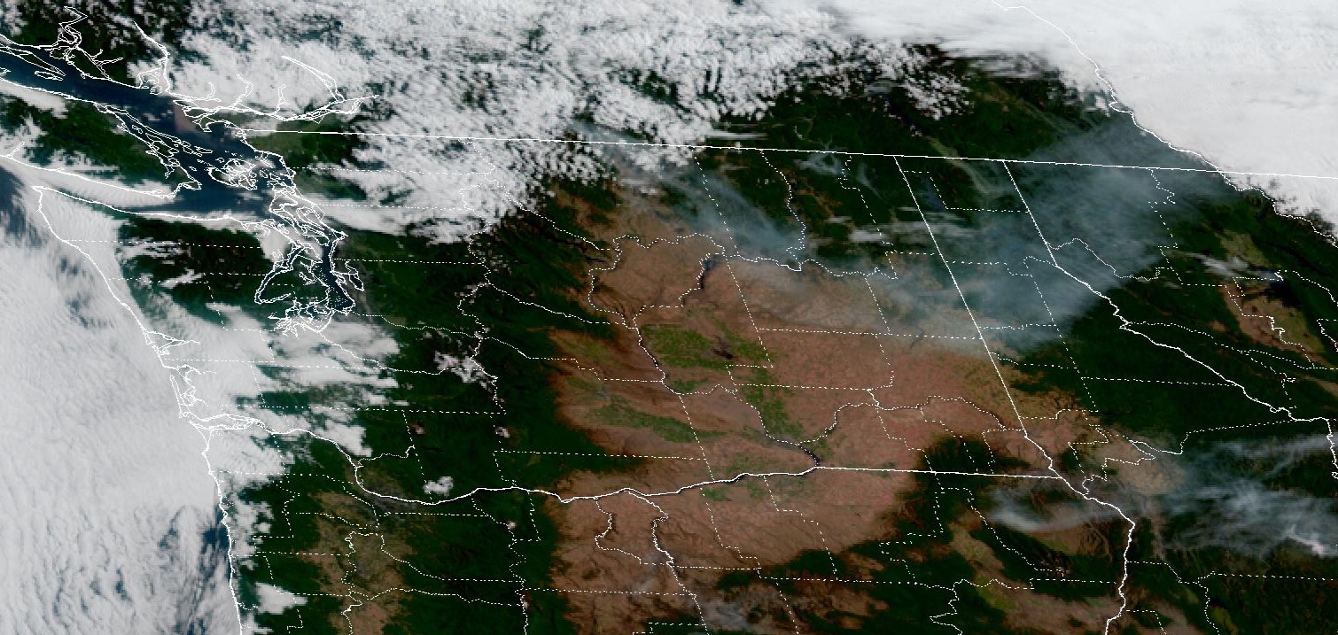
Pyrocumulus clouds billowing above the smoke plume of the Pomas Fire Monday evening. Image courtesy: Lake Wenatchee Fire & Rescue

The fire grew approximately 415 acres on Monday, bringing the fire perimeter to 2,890 acres.

Despite the impressive smoke plume, air quality across eastern Washington is mostly in the green as the smoke aloft has remained aloft as it dispersed to the east.

The greatest smoke impacts from the fire will continue to be in the Entiat River valley, where UNHEALTHY conditions will continue to be possible each morning following active fire behavior. Air quality is expected to improve to GOOD in the afternoon.

Gusty winds Tuesday afternoon and evening followed by a dry cold front Wednesday may limit overnight drainage and actually reduce these smoke impacts, but these winds and low relative humidity will bring critical fire conditions to the region.

Apple Acres Fire

The Apple Acres Fire is approximately 3,410 acres and 70% contained. With Red Flag Warnings in place, fire activity may increase Tuesday and Wednesday. The remaining fuel the fire could burn is mostly comprised of grass, so any potential smoke impacts will be in the immediate vicinity of the fire.

Thursday, July 3, 2025

Wishing You a Happy and Safe Fourth of July!


Weekend Weather

Seasonable conditions are expected to return today and tomorrow. There is a small chance for isolated thunderstorms in the southeast region early Friday morning and again for Friday evening, but widespread thunderstorms are not expected. Going into the weekend, we do expect a general warming and drying trend with well above average temperatures for the early part of next week.


Current Fire Situation

There are currently 3 named fires in Washington (Pomas, Siegel, and Apple Acres) that remain active. In spite of that, air quality is looking GOOD overall with MODERATE levels showing up in those areas closest to the fires.


Firework Safety

While we all love great firework shows, it’s important to take safety into consideration. Please keep in mind that fireworks not only contribute to smoke but also are responsible for starting new fires. Fires can start and spread much more easily in hot and dry conditions. Please exercise extreme caution if igniting fireworks. If recreating, check local fire restrictions and consider if a campfire is necessary. 

For more safety tips, check out WA Department of Health's Public Health Tips for the Fourth and be sure to keep an eye on this blog for future updates and current air quality.