Tuesday, July 11, 2017

BC wildfire smoke still affecting north central WA

The Methow Valley is very hazy as shown by the Sun Mountain Lodge webcam.


Pollution levels spiked in many areas in and around over Okanogan county today and has commenced its slow daytime decline.


The fire in British Columbia mentioned in the previous post continues to be the culprit, with smoke mixing to the surface when the overnight temperature inversion breaks. The satellite picture this morning shows smoke pouring down the Okanogan river valley.


Air quality in the area is expected to vary between Moderate and Unhealthy in the area with a slow improvement over the rest of today. Winds are expected to shift to the southwest and help return the smoke back to Canada with a "no thank you" note. But smoke lodged in more sheltered valleys might have a harder time getting scrubbed out, so expect areas of Moderate to USG to persist until tomorrow.

Rest of the state should see mostly Good air for the next few days, except close to some fires where Moderate or USG conditions can be expected during overnight hours.

Saturday, July 8, 2017

BC wildfire smoke affecting northern WA

Smoke from a fire near Princeton, BC has been affecting parts of Okanogan, Ferry and Stevens counties over the last few mornings. This afternoon's satellite picture shows smoke from the (circled) fire.


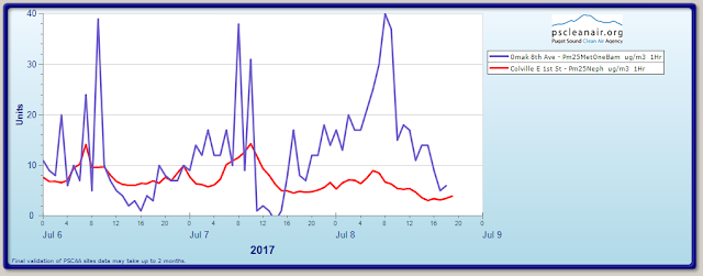
The fine particle pollution monitor in Omak bears out the evidence most prominently. Notice how levels spiked over the last 3 mornings.


This happens when (1) northwest flows overnight transport smoke into the area via the Okan(a)ogan river valley, followed by (2) the inversion layer breaking up as the morning sun heats the ground, and (3) smoke aloft mixes to the surface. But daytime winds switch to the southwest and help dissipate smoke- albeit slowly. 

Expect another round of the same smoke behavior in the north central counties from Sunday to Tuesday. Periods of Moderate and USG air are likely during the overnight and morning hours. Unhealthy air in communities such as Oroville and Tonasket cannot be ruled out.

And finally, be prepared for more fire concerns on Sunday, followed by a progressively hotter work week.

Friday, July 7, 2017

Smoke forecast Friday 7/7- Monday 7/10

Currently air quality is mostly Good statewide, with a few Moderate areas sprinkled in. There are several brush fires burning and air quality is likely to be compromised closer to them.

Of immediate concern is the Red Flag Warning for much of eastern WA today. This graphic from the National Weather Service says it all:


A fair amount of fuels in WA are dry enough to burn, as indicated by the FPI index below (OK nothing like the desert southwest!)


While stronger winds will transport smoke from fires around the Cascade Foothills to parts of the Columbia Basin, fine particle pollution (PM2.5) is likely to be somewhat dispersed and I dont expect air quality to degrade much worse than Moderate later today. However as winds lighten over the weekend, communities such as Wenatchee, Quincy and Sunnyside could potentially see a few hours of Unhealthy for Sensitive Groups (USG) air, mostly at night and early morning. Expect mostly Good to Moderate air in other areas of eastern Washington.

No major storms or winds are expected over the next week. Temperatures are expected to remain close to or just above normal. Firefighting isnt going to be easy so lets do our best to prevent fires.

Wednesday, July 5, 2017

Residual smoke from fireworks in western WA today

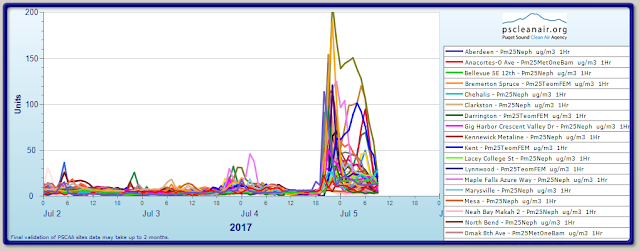
Light winds in much of Washington over the last 2 days caused smoke from fireworks to accumulate in many communities.  The chart below shows fine particle pollution levels spiking after 6PM on the 4th of July. A smaller spike was observed on the 3rd.


Pollution levels are still dissipating and we expect Good air quality to return later today.

Smoke from any new fires that started in the last day, whether due to fireworks or other reasons, will likely be confined to nearby areas as winds are expected to remain light until about Thursday evening. Expect mostly Good air quality statewide, with a few Moderate periods.

Monday, July 3, 2017

Smoke forecast for Independence Day holiday

Biggest concern is the dry, gusty winds expected along the east slopes of the central Cascades through tonight. There is a strong possibility of rapid fire spread and a Red Flag Warning has been issued.


Smoke from fires east and west of Yakima is expected to blow across the central and northeastern Columbia Basin today but air quality is expected to remain mostly Good, except right by the fires where Moderate or Unhealthy for Sensitive Groups can occur overnight.

As winds die down and temperatures ramp up on and after the 4th of July, smoke from existing and new fires is likely to linger in the area. Some cities in Yakima county could see Moderate or USG conditions at times.

No major smoke concerns are expected in western Washington over this period. Have a safe and happy 4th of July!

Wednesday, June 28, 2017

6/28/17 Wildfire smoke affecting Grant, Douglas, Kittitas counties


Smoke from wildfires southeast of Wenatchee and northwest of Quincy are causing air quality conditions from Moderate to Unhealthy in Grant and Douglas counties. The Sutherland Canyon, Spartan, and Straight Hollow fires are approximately 10-30% contained, but gusty winds are in the forecast, likely to push smoke into Douglas County and northern Grant County today, June 28, and towards Kittitas County and Wenatchee after 1PM on June 29. View fire details and possible evacuation information at the "Where's the Fire" tab above or visit InciWeb.


Locations of fire as of this post, June 28 approximately 11AM.
See more details in the interactive map at the top of the blog page.


Monday, June 26, 2017

6/26/17 Smoke Blog Update


We’re back for the 2017 Wildfire Season.  We’ve already had a few fast moving fires in Central WA over the past week and the forecast today http://www.youtube.com/NWSSpokane  looks like high potential for rapid fire growth if we get any new ignitions. May see some localized dust issues with high winds forecasted in front of these fast moving weather systems. High wildfire potential in areas with numerous lightning strikes, high winds and fine fuels like sage shrub steppe and the Eastern WA landscape. Please be sure to stay tuned to local emergency management and watch the local news for updates on any new fires.  These fires don’t typically cause widespread and long lasting smoke events but can move fast and cause localized evacuations and visibility issues on roads as well as localized health impacts from blowing dust and smoke.

Remember stay safe over the 4th of July weekend and follow all local fire safety burn bans and firework regulations.

Today’s Modis Satellite Image (11am) No visible smoke plumes but lots of active weather.


Tuesday, September 13, 2016

9/13/2016 Using Prescribed Fire and Measuring Impacts to Air Quality

In the Spring of 2016, the Washington State Legislature passed House Bill 2928, the Forest Resiliency Burning Pilot project. The goal of the pilot project is to examine the role that prescribed fire can play in creating healthier, more resilient forests. Of course prescribed fires produce smoke, so one important part of the pilot is monitoring the quantity and severity of any air quality impairment caused by the prescribed fires.

A major challenge when using prescribed fire is to simultaneously protect air quality from the inevitable smoke that is produced. To the greatest extent possible, prescribed fires are planned for days when winds and weather will keep smoke away from populated areas. Although sometimes the best days to safely use fire in the forests are not the best days to protect air quality.

Most of the proposed pilot burns are in fairly remote parts of the state meaning some small, nearby communities are not well represented by the extensive permanent air quality monitoring network operated by the Washington Department of Ecology. To determine the effect of prescribed burning on air quality in these more remote parts of the state, nine new temporary air quality monitors have been deployed to supplement the permanent monitoring network already in operation. New monitors have been placed in Curlew, Kettle Falls, Sherman Creek Hatchery, Usk, Manson, Plain, Liberty, Naches, and Nile. In addition, permanent monitors in Winthrop, Chelan, and Leavenworth will be scrutinized for smoke impacts from forest resiliency burning (see image below). Many of the temporary monitors now also display on our blog map (above) as triangles.

Washington Department of Natural Resources is leading the effort with the help of many partner agencies and organizations. More about the Forest Resiliency Burning Pilot can be found here: http://www.putfiretowork.org/


New fires in eastern WA. Prescribed burning likely

The Rock Creek fire on SR410 near Cliffdale is causing Moderate air around Naches. Expect air quality to vary between Moderate and Unhealthy for Sensitive Groups overnight in Naches, Yakima, Tieton and Cowiche, with daytime clearing through Friday. The Kittitas valley could see a little overnight smoke from this fire after Wednesday. 

In the lower Colombia Gorge, two fires are burning light fuels near Roosevelt. Areas from Wishram to Lyle will see a some smoke settling overnight, leading to ModerateUnhealthy for Sensitive Groups air.

It should be noted that several prescribed burns are planned throughout the Okanogan-Wenatchee National Forest in the coming days and weeks, and the public may see smoke as a result. 

Northeast winds blowing across the state will slacken early Wednesday, meaning colder overnight temperatures, calmer winds, and higher relative humidities, aiding fire fighting efforts. We should have less and less smoke as the week wraps up.

Here's a snapshot of the statewide forecast for Wednesday

Thursday, September 1, 2016

Moderate air expected in parts of Chelan county over the long weekend

Winds in Chelan County last evening turned out to be stronger than expected, resulting in Good air quality.

Cloudy skies with moderate winds an occasional showers will be the norm for most of the long weekend. This will keep fire activity in check and also help disperse smoke.

The Buck Creek and Saul fires are likely to cause some smoke impacts nearby, particularly in the evenings and nights. Expect air quality at Coles Corner, Plain, Leavenworth, Wenatchee and Chelan to be no worse than Moderate on occasion. Good air quality is expected during the day.

No major smoke concerns elsewhere in the state.