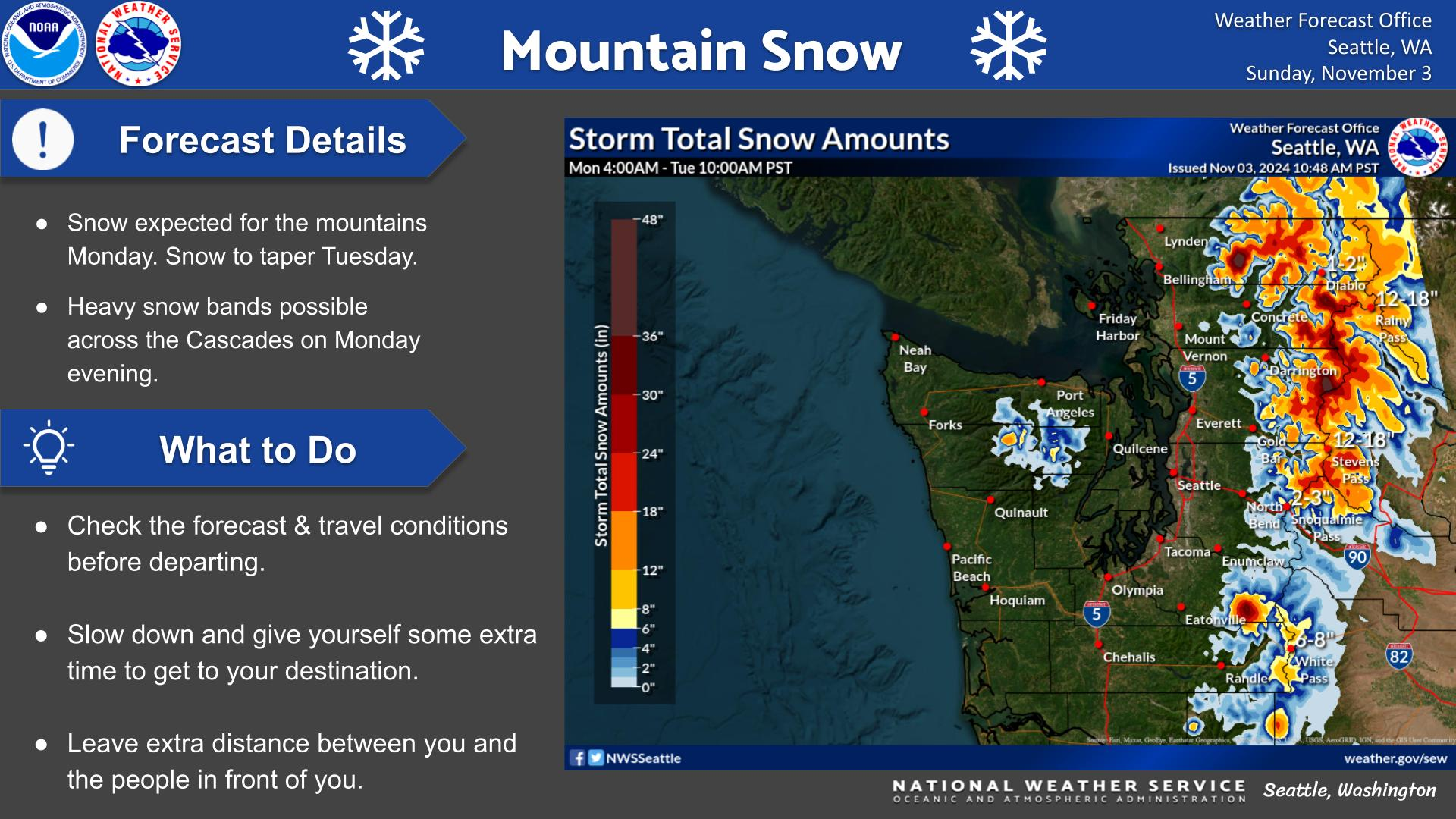
Satellite imagery shows the remnant wildfire smoke haze dispersing this morning, but some fires are still producing visible smoke plumes. We also expect easterly winds over the next few days and a Red Flag Warning is in effect for the West Cascade slopes of Lewis, Pierce, and King county due to dry and windy conditions. With the expected wind shift, a moderate amount of BC smoke is expected to drift down into the Puget Sound region this weekend. No Air Quality Alerts are planned at this time, but Moderate to USG smoke will likely impact northern counties for a couple days.
Residents in Okanogan have been living with intermittent smoke from nearby BC fires for quite some time, and that will continue. The fires in British Columbia continue to dwarf what is going on in our state. However, a low pressure system is expected to cause rain showers across the Pacific Northwest on Tuesday, and this should help limit temperatures and smoke production across the region. BC officials also report that there has been good progress on containing fires and some evacuees are being allowed to return home.
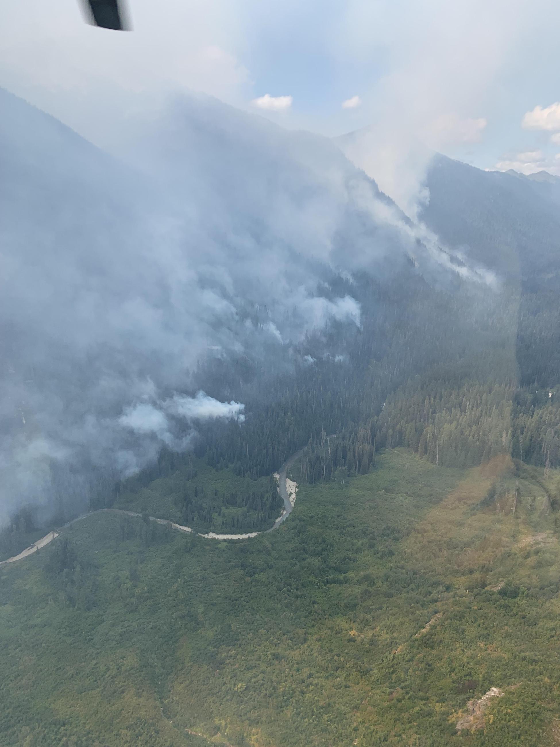
The Airplane Lake fire (2,300 acres) in the Glacier Peak Wilderness Area of Chelan County has been pushing smoke into the Wenatchee region. However, winds are shifting and Snohomish County communities like Darrington and Gold Bar will probably smell smoke over the next couple days. There are trail closures in the area around the fire.
The Sourdough fire (6,000 acres) in Whatcom County near Ross Lake is partially contained and firefighters report that opening SR-20 to thru traffic was a success. However, sensors around the Diablo Lake region are showing intermittent smoky conditions and trail closures are still in effect.
The Oregon fire in Spokane County is partially contained and firefighters continue to make great progress. Very little smoke is being generated at this time.
See the Health Information Tab on this blog for more information about how you can protect yourself from wildfire smoke. See the Local Smoke Outlooks for detailed forecasts in your area. Check WatchDuty for frequently updated information on local fires.
*** Update***
The Lookout Fire in Oregon is pushing smoke high into the atmosphere and being transported to the north, contributing to the haze over the region. Fire crews have progressed with firing operations designed to strengthen control lines, and fire growth has been considerable, contributing to the large smoke production.
Good morning, I noticed on the public ECY air monitoring website that new mobile air monitors have been set up in towns like Oroville, Entiat and Manson. I am curious what type of air monitoring samplers are these and which regional office set them up. Thanks, Scott Honodel (former ECY)
ReplyDeleteHi Scott! These are Ecology's portable low-cost PM2.5 sensors, and they were set up by the Central Regional Office.
DeleteThank you Beth :)
ReplyDeleteHello Beth (and/or other folks at WA Ecology). We're wondering if you might have an updated forecast for smoke over the labor day weekend? I've looked at https://enviwa.ecology.wa.gov/home/text/421#Forecast, for example, but it seems to give contradictory information depending on if you look at the colored vs plume versions of the forecast (e.g., on Sep 1st, green is shown in the western WA region but at the same time the plume image shows light to moderate smoke, but perhaps I'm misinterpreting something). Thanks again for providing this valuable and informative blog that you do!!!
ReplyDeleteThanks for your question. I'll try to unpack all this. 1) It's going to rain quite a bit this week, so I would expect smoke production to be reduced in the coming days (though Labor day weekend is still several days out); 2) The plume image is the average of the 8 HYSPLIT runs that Ecology does with no manual intervention and no clean air agency input (and HYSPLIT doesn't have deposition from rain in the simulation, it's just a plume and dispersion simulator); 3) Western Washington is covered by Clean Air Agencies that submit their forecasts to AirNow (which is what's shown on the AQI colored map; see here: https://enviwa.ecology.wa.gov/Documents/SmokeForecast.pdf ). Please let us know if you have any other questions.
DeleteThere should have been air quality alerts this weekend as the PM 2.5 AQI was well over 100 in my area over the weekend. The clearing predicted on Tuesday is not happening and there is not update as when to expect clean air. Also, I feel this blog was not updated enough this season. Many of us depend on this blog to get through the smoke season. While I appreciate what you do, you did a lot less this year than previous years on informing the public on how to remain safe. I know you won't post my comment but I wanted you to know that you need to do more, like you have done in the past.
ReplyDeleteAn AQI of 100 is equivalent to "Moderate". By the NWS definition, an Air Quality Alert is only to be issued for "Unhealthy" air or worse (AQI of 150 or higher for a daily average). Concerning your opinion about our lack of information compared to previous years, perhaps you are just looking at "new posts". If so, you are missing most of the content on this blog. There is a 5-day forecast map that is updated daily on the blog. Also, there are several Local Smoke Outlooks that are updated daily that you should review if you are looking for more detailed information. I suggest you use those forecasts because we spend a lot of time developing them daily. There are many tools and links on this blog that should be reviewed if you are looking for ways to protect yourself from smoke, not just "new posts". You are also welcome to post comments and ask questions if need more information.
DeleteHi Farren- can you shed a little light on the differences between what Apple Iphone IOS weather updates provide regarding air quality and the information on your maps above? I am sitting in Richland, WA. According to the map above, our air should be Good. As I look outside, I see quite a bit of haze toward the east, obscuring Kennewick and Pasco. Additionally, my Iphone weather app shows our air quality at 120. Currently it shows a large, orange ball of bad air over the Tri Cities area on the map. When I look at another air quality application I have called AirVisual, it is also showing Tri Cities in the green with good air. Your map above is showing good air. So I am confused. Which one is the most accurate- or can you explain the discrepancy?
ReplyDeleteYesterday in the tri-cities area, air quality fluctuated between good and moderate. Smoke higher up in the atmosphere might have been contributing to the haze you were seeing. The map at the top of this page includes permanent air quality monitors operated by state, local, and tribal air quality professionals (circle symbols), temporary monitors deployed by agencies (triangles), and privately owned low-cost sensors from Purple Air, with EPA's correction equation applied (squares). The monitoring data is reported and averaged hourly, and the dots and their colors on the map are a "NowCast", which relates the current and previous hourly PM2.5 concentrations to the Air Quality Index. The NowCast is meant to give you a sense of what precautions you should take now, based not on just the most recent concentration but also on trends--the NowCast uses longer averages during times when air quality is stable and shorter averages when air quality is quickly changing.
DeletePrivate companies like Apple and AirVisual are not subject to the same requirements around data transparency and quality assurance that guide public monitoring agencies such as the Department of Ecology. AirVisual says that sensor data are "subjected to a data calibration and correction process", but does not provide details about what this process actually entails. Similarly, the air quality data used in the iphone weather app also does not provide information about their data sources, averaging times, and quality control processes, and since their data doesn't match official data channels I can't provide much more information. I would encourage you to look to public agency sources for trusted air quality information.
What's the cause of the sudden increase in smoke in the Portland / Vancouver area? Are the rains quenching the Camp Creek fire and producing more smoke?
ReplyDeleteLooks like the near-surface winds in the cool hours are pushing smoke right into that area from the Camp Creek fire. The forecasted rain should help out, but those near-surface wind patterns could cause a repeat tomorrow morning.
Delete