Sunday, September 30, 2012

9/30/12 Wildfire Smoke Forecast 0800 PDT

9-30-12 Air Monitor Update 0800 PDT
Central Region Ecology Air Quality Report  
Chelan County:
Wenatchee- Unhealthy for sensitive groups
Leavenworth-  Good
Chelan- Good
Okanogan County:
Omak - Good
Winthrop – Good
Twisp-   Good
Kittitas County:
Ellensburg- Good
Yakima County:
Yakima- Good
White Swan- Good
Toppenish- Klickitat County:
Goldendale- Good

Eastern Region Ecology Air Quality Report
Blue Mt. Area
Clarkston  -  Good
Dayton  -   Good
Walla Walla  - 
Good
Palouse Area
Pullman  - 
Good
Rosalia  - 
Good
LaCrosse  - 
Good
Northeast
Colville  - 
Good
Wellpinit  - 
Good
Central Washington Air Quality Report from Forest Service Temporary Monitor Locations
Chelan County:
Wenatchee(Confluence Park)- Good
Cashmere- Good
Entiat- Good
Okanogan County:
Pateros- Good
Grant County:
Quincy-  Good
Kittitas County:
Liberty – off line
Cle Elum- Good
Klickitat County
Trout Lake- Unhealthy


Eastern cont., Ecology Air Quality Report
Columbia Basin
Kennewick  -  Good
Mesa  -
Good
Moses Lake  -
Good
Ritzville  -
Good
Spokane Area
Spokane, -
Good
Liberty Lake -
Good

Another very useful webpage for a grab hourly and 24 hour data, Puget Sound Clean Air and their air quality tool: http://airgraphing.pscleanair.org/
Remember the Eastern Washington Burn Ban remains effective through Sunday, September, 30, 2012.
9/30/12 Wildfire Smoke Forecast 0800 PDT
Air Quality forecast, 8AM Sunday 30 September 2012
Issued by Ranil Dhammapala, Washington State Dept. of Ecology
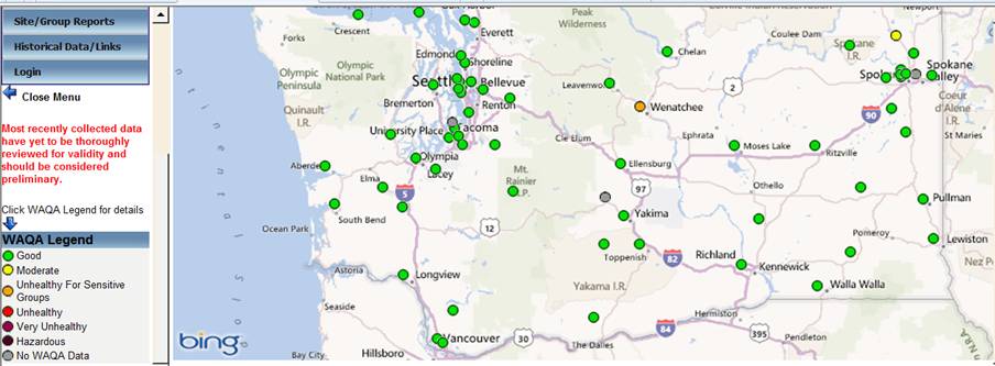
     A passing cold front brought smoke clearing as anticipated yesterday, and it was nice to see mostly green dots on the map of monitors after quite some time. After showing Good air for about 10 hours, Wenatchee jumped to Unhealthy for Sensitive Groups within two hours this morning. Trout Lake is reporting Unhealthy air, mainly due to smoke impacts this morning. Cashmere and Entiat (currently Good) are also on the rise. Other than these monitors, Deer Park and Maple Falls (both Moderate), all other fine particle monitors in WA are reporting Good air. Ritzville, Moses Lake, Wellpinit and Colville saw some short term spikes last evening, most probably as smoke was exiting through the Columbia Basin.
     Today should see moderate winds with smoke impacts in communities near the fires. Smoke is likely to drift into the Columbia Basin, but not fill it. Expect some afternoon clearing. Areas to the east of the Basin are likely to see little or no smoke through Monday evening. A strong cold front is expected Tuesday but winds will start increasing by Monday evening and help with smoke dispersion. While precipitation appears to be confined to the North Cascades and the far NE part of the state, winds will likely kick up windblown dust in the Columbia Basin on Tuesday.
     The National Weather Service issued an Air Quality Alert for all of eastern Washington:
http://forecast.weather.gov/wwamap/wwatxtget.php?cwa=otx&wwa=air%20quality%20alert
     The Governor has extended a burn ban on all outdoor burning in eastern Washington through midnight Sunday.
Ecology Air Quality Monitoring Network Map: https://fortress.wa.gov/ecy/enviwa/Default.ltr.aspx
  - when browsing the monitoring web page, click on the dots and you can then click on View more information to find out the latest hourly values even if the dot is grey


Saturday, September 29, 2012

9/29/12 Wildfire Smoke Forecast 0800 PDT

9-29-12 Air Monitor Update 0800 PDT
Central Region Ecology Air Quality Report  
Chelan County:
Wenatchee- Very unhealthy  
Leavenworth- Unhealthy for sensitive groups
Chelan- Unhealthy
Okanogan County:
Omak - Unhealthy for sensitive groups
Winthrop – Moderate
Twisp-  Moderate
Kittitas County:
Ellensburg- Good
Yakima County:
Yakima- Unhealthy for sensitive groups
White Swan- Moderate
Toppenish- Unhealthy for sensitive groups
Klickitat County:
Goldendale- Moderate

Eastern Region Ecology Air Quality Report
Blue Mt. Area
Clarkston  -  Unhealthy for Sensitive Groups
Dayton  -   Good
Walla Walla  - 
Moderate
Palouse Area
Pullman  - 
Moderate
Rosalia  -  Moderate
LaCrosse  -  Moderate
Northeast
Colville  - 
Moderate
Wellpinit  - 
Moderate  
Central Washington Air Quality Report from Forest Service Temporary Monitor Locations
Chelan County:
Wenatchee(Confluence Park)- Hazardous
Cashmere- Very Unhealthy
Entiat- Hazardous
Okanogan County:
Pateros- Unhealthy
Grant County:
Quincy-  Unhealthy
Kittitas County:
Liberty off line
Cle Elum- Good
Klickitat County
Trout Lake- Unhealthy


Eastern cont., Ecology Air Quality Report
Columbia Basin
Kennewick  -  Unhealthy for Sensitive Groups
Mesa  - Unhealthy for Sensitive Groups 
Moses Lake  - Unhealthy for Sensitive Groups
Ritzville  - Moderate 
Spokane Area
Spokane, - Unhealthy for Sensitive groups
Liberty Lake - Unhealthy for Sensitive Groups

Another very useful webpage for a grab hourly and 24 hour data, Puget Sound Clean Air and their air quality tool: http://airgraphing.pscleanair.org/
Remember the Eastern Washington Burn Ban remains effective through Sunday, September, 30, 2012.
9/29/12 Wildfire Smoke Forecast 0800 PDT
Air Quality forecast, 8AM Saturday 29 September 2012
Issued by Ranil Dhammapala, Washington State Dept. of Ecology

     Other than Wenatchee (Very unhealthy) and Chelan (Unhealthy), other monitors at the Cascade foothills and Columbia Basin are reporting a mix of Unhealthy for Sensitive Groups, Moderate and Good. Several of the USFS temporary monitors have incomplete data this morning, so the WAQA categories are not current. At midnight, air in Cashmere was Very Unhealthy, while Entiat and the USFS Fire camp at Wenatchee Confluence Park was reporting Hazardous air. Other nearby monitors have shown a decline in more recent hours, so it is possible these areas are no longer experiencing Hazardous air. 
Pateros, Quincy and Trout Lake saw Unhealthy air at midnight, while Cle Elum reported Good air. 
     Most of western WA except the Olympic Peninsula saw a little smoke and haze yesterday but the front that moved in last evening has returned air quality at all but two monitors to Good. Most monitors at the Cascade foothills have shown a downward trend over the last few hours in response to this front. Expect clearing to continue through Saturday evening and bring some relief to the smoke impacted communities of the Cascade foothills today. However the smoke will blow through the Columbia Basin while dispersing. Winds die down tonight and become more terrain-driven on Sunday and Monday, meaning nighttime and morning smoke in several areas with daytime clearing. 
     No easterly winds are expected, so there is no threat of Idaho wildfire smoke over the next few days, nor is smoke likely to move into western WA. A strong cold front is expected to move through eastern WA around Tuesday but doesn’t appear to contain a huge amount of precipitation.
The National Weather Service issued an Air Quality Alert for all of eastern Washington:
http://forecast.weather.gov/wwamap/wwatxtget.php?cwa=otx&wwa=air%20quality%20alert
     The Governor has extended a burn ban on all outdoor burning in eastern Washington through midnight Sunday.
Ecology Air Quality Monitoring Network Map: https://fortress.wa.gov/ecy/enviwa/Default.ltr.aspx
  - when browsing the monitoring web page, click on the dots and you can then click on View more information to find out the latest hourly values even if the dot is grey


Friday, September 28, 2012

9/28 Air Quality in Cle Elum is being monitored again

Yesterday the Forest Service temporary air monitor that had been in Cle Elum was moved to Liberty to look for impacts from planned back burning being conducted on the Table Mountain Fire. So for a short time Cle Elum was without a monitor.  But starting today (9/28) at about 11am a new Cle Elum monitor was up and operating.  Values recorded by “Smoke 15” can be accessed here:

Important:  You need to subtract 7 hours from the time given for the readings on the Forest Service Smoke monitors to get local time.  Also, there is a link on the right hand side of this WA Smoke blog page called “Interim Guidance for Wildfire Smoke and WAQA” that will help you determine the approximate health warnings associated with the readings given by the Forest Service monitors.  The values and health alerts available from State Department of Ecology monitors are best if you’re near one.  If not, using values from the Forest Service monitors along with the table in the Guidance document should help you take appropriate health precautions.

(And unfortunately it appears the Liberty monitor (Smoke 66) has malfunctioned and is not transmitting. We’ve got some folks on the way to see if that can be remedied.)

Do you have smoke or air quality questions?

This Blog is being created and maintained by cooperators from the Forest Service, Department of Ecology, Environmental Protection Agency, and numerous Public Health agencies to help keep citizens informed about air quality impacts from the unprecedented levels of smoke from wildfires in Washington the last few weeks.  Please let us know if you have questions or concerns and we’ll try to get an answer up as soon as possible.  Click on the comments link at the bottom of this post to ask your question.
Thanks and stay safe!


9/28/12 930 Ecology's Friday smoke conditions and weather forecast

Washington Department of Ecology news

FOR IMMEDIATE RELEASE – Sept. 28, 2012

Air quality erodes in some communities; may improve over weekend 
OLYMPIA – Continuing wildfire smoke has driven air quality into the “hazardous” and “very unhealthy” ranges in several Central Washington communities, according to the Washington Department of Ecology (Ecology).
This morning (Friday, Sept. 28, 2012), a newly relocated air monitor showed air quality was “hazardous” in Liberty. Air also was “hazardous” in Cashmere, and “very unhealthy” in Wenatchee and Trout Lake. Entiat experienced “unhealthy” air; Pateros and Quincy were in the “unhealthy for sensitive groups” range.
Air quality in most locations across Eastern Washington registered as “moderate” to “unhealthy for sensitive groups.” Only Colville, Wellpinit and Dayton are experiencing “good” air quality.
Many communities are experiencing a pattern – smoke clears in the mid- to late afternoon so air quality improves, then smoke builds up again overnight and air quality deteriorates.
Today’s forecast calls for winds to increase this evening as a weakening cold front moves into Eastern Washington. Weekend winds are expected to move smoke out of the region.
However, said Ecology forecaster Clint Bowman, “there is no precipitation in the forecast sufficient to affect the wildfires, and smoke will continue to be an air quality problem into next week as the surface winds subside.”
The National Weather Service issued an Air Quality Alert for all of Eastern Washington: http://forecast.weather.gov/wwamap/wwatxtget.php?cwa=otx&wwa=air%20quality%20alert
Gov. Chris Gregoire has banned all outdoor burning in Eastern Washington through midnight Sunday. The ban does not apply to tribal lands where the U.S. Environmental Protection Agency has jurisdiction.

More information:


9/28/12 Wildfire Smoke Forecast 0800 PDT

9-28-12 Air Monitor Update 0800 PDT
Central Region Ecology Air Quality Report  
               Chelan County:
Wenatchee- Hazardous
Leavenworth- Unhealthy
Chelan- Unhealthy for sensitive groups
Okanogan County:
Omak - Moderate
Winthrop – Unhealthy for sensitive groups
Twisp-  Moderate
Kittitas County:
Ellensburg- Very Unhealthy
Yakima County:
Yakima- Unhealthy for sensitive groups
White Swan-Unhealthy for sensitive groups
Toppenish- Unhealthy for sensitive groups
         Klickitat County:
Goldendale- Moderate

Eastern Region Ecology Air Quality Report
Blue Mt. Area
Clarkston  -  unhealthy for sensitive groups
Dayton  -   good
Walla Walla  -  moderate
Palouse Area
Pullman  -  unhealthy for sensitive groups
Rosalia  -  moderate
LaCrosse  -  moderate
Northeast
Colville  -  good
Wellpinit  -  good  
Central Washington Air Quality Report from Forest Service Temporary Monitor Locations
Chelan County:
Wenatchee(Confluence Park)- “Very Unhealthy”
Cashmere- “Hazardous”
Entiat- “Unhealthy”
Okanogan County:
Pateros- “Unhealthy for sensitive groups”
Grant County:
Quincy-  “Unhealthy for sensitive groups”
Kittitas County:
Liberty - “Hazardous”
Klickitat County
Trout Lake- “Very Unhealthy”


Eastern cont., Ecology Air Quality Report
Columbia Basin
Kennewick  -  moderate
Mesa  - moderate 
Moses Lake  - moderate
Ritzville  - moderate
Spokane Area
Spokane, - unhealthy for Sensitive groups
Liberty Lake - unhealthy for Sensitive Groups

Another very useful webpage for a grab hourly and 24 hour data, Puget Sound Clean Air and their air quality tool: http://airgraphing.pscleanair.org/
Remember the Eastern Washington Burn Ban remains effective through Sunday, September, 30, 2012.
9/28/12 Wildfire Smoke Forecast 0800 PDT
Air Quality forecast, 8AM Friday 28 September 2012
Issued by,
Clint Bowman, Washington State Dept. of Ecology
The air quality in Liberty and Cashmere registered as Hazardous this morning. While Wenatchee and Trout Lake came in as Very Unhealthy.  Much cleaner, but still Unhealthy, Entiat.
Pateros and Quincy were in the Unhealthy for Sensitive Groups.  The past few days have had a good diurnal (daily) cycle of clearing in mid to late afternoon with increasing concentrations peaking just before sunrise.
On across Eastern Washington most locations are experiencing Moderate to Unhealthy for Sensitive Groups air quality.  Only Colville, Wellpinit, and Dayton are in the Good air quality area.
Today expect the air quality to start out much the same as yesterday before a weakening cold front kicks up winds this evening.  Over this weekend the mid-level winds will gradually increase and gradually work their way downward to begin to move the smoke out of the region.  There is no precipitation in the forecast sufficient to affect the wildfires and smoke will continue to be an air quality problem into next week as the surface winds subside.
Air Quality Alerts are in effect for Eastern Washington <https://nwschat.weather.gov/p.php?pid=201209272323-KOTX-AEUS76-AQAOTX>
The Governor has extended a burn ban on all outdoor burning in eastern Washington through midnight Sunday.

Ecology Air Quality Monitoring Network Map: https://fortress.wa.gov/ecy/enviwa/Default.ltr.aspx
  - when browsing the monitoring web page, click on the dots and you can then click on View more information to find out the latest hourly values even if the dot is grey


Thursday, September 27, 2012

9/27/12 EPA Continues Burn Ban for Yakama Reservation and the Warm Springs Reservation. Also an Air Quality Advisory will continue in Effect for the Colville and Spokane Reservations  

 The U.S. Environmental Protection Agency (EPA) Region 10 will continue a burn ban on all outdoor burning on the Yakama Reservation and the Warm Springs Reservation through till Monday, October 1st due to the impact of smoke from wild fires.  This smoke has caused monitor readings to approach and at time exceed the unhealthy level for sensitive groups.  Weather patterns and expectations for control of these wild fires would indicate that conditions will not improve significantly over the next several days.  Therefore these burn bans will be in place through till Monday, October 1st when the situation will be re-evaluated.
These burn bans apply to all outdoor and agricultural burning, including camping and recreational fires within reservation boundaries.   Ceremonial and traditional fires are exempt from the outdoor burn ban.

Also an Air Quality Burn Advisory will continue in effect for the Colville and the Spokane  Reservations. 
  EPA requests that residents and businesses on these reservations refrain from outdoor burning including agricultural, forestry, and recreational fires within reservation boundaries. This advisory will be reviewed on Thursday, October 1st..
EPA also requests that reservation residents reduce all sources of air pollution, including excess driving and idling of vehicles, and the use of woodstoves and fireplaces, unless it is your only source of heat.

Air pollution can have significant health impacts.  Cooperation from the community will help people who are at risk during this period.  Those most at risk are children, the elderly, pregnant women and those with difficulty breathing and with heart and lung problems.  Those at risk should avoid outdoor exercise and minimize exposure to outdoor pollution as much as possible.

Please call 1-800-424-4EPA and ask for the FARR Hotline or visit the Federal Air Rules for Reservations (FARR) website for the current burn status at
www.epa.gov/r10earth/FARR.htm.

9-27-2012 1145 Thursday's Ecology conditions update and forecast

Washington Department of Ecology news

FOR IMMEDIATE RELEASE – Sept. 27, 2012

12-326


Air quality worsens again in Wenatchee, Cashmere
OLYMPA – Wildfire smoke has poured back into the Wenatchee and Cashmere areas, plunging air quality there back into the “hazardous” category, according to the Washington Department of Ecology (Ecology).
Both communities have been hammered by smoke carried by winds from area wildfires. Some afternoon clearing occurs when the inversion breaks and upvalley winds kick in. On Wednesday (Sept. 26), Entiat and Pateros showed air quality as “unhealthy for sensitive groups,” while air was “unhealthy” in Leavenworth. Twisp, Winthrop and Cle Elum (all “moderate”) showed the opposite trend, with increasing fine particle pollution levels recorded when winds during the day pushed smoke toward air quality monitors.
Monitors showed air quality was “unhealthy” in Trout Lake and Ellensburg, “unhealthy for sensitive groups” in Yakima and Toppenish, and “moderate” in White Swan and Goldendale. All of those communities saw an increase in fine particle pollution when the inversion broke. But they experienced some partial clearing later on Wednesday.
Omak and Quincy air monitors are reading “good,” but fine particle monitors elsewhere east of the Cascades are reporting compromised  air quality today (Thursday, Sept. 27). Columbia Basin monitoring sites show little change since Wednesday, with a mixture of “moderate” air to “unhealthy for sensitive groups.”
Light east winds have started in Eastern Washington and could still bring some smoke from Idaho wildfires to the Palouse before Friday night. With strong nighttime inversions, above normal daytime temperatures and light winds, the largest smoke impacts are expected near the fires while the Columbia Basin will continue to experience a steady state in which as much smoke enters as leaves.
In general, expect some smoke impacts in the morning and nighttime, with some afternoon clearing in most places. The light east winds could push some smoke farther up the Cascade foothills during the day.
Winds are expected to pick up on Friday evening; models suggest that gradual clearing in most areas is expected to continue through Saturday evening before calm conditions return.
The National Weather Service issued an Air Quality Alert for all of Eastern Washington: http://forecast.weather.gov/wwamap/wwatxtget.php?cwa=otx&wwa=air%20quality%20alert
Gov. Chris Gregoire has banned all outdoor burning in Eastern Washington through midnight Sunday. The ban does not apply to tribal lands where the U.S. Environmental Protection Agency has jurisdiction.

###

Media Contact: Seth Preston, Ecology communications manager, 360-407-6848; 360-584-5744 cell; seth.preston@ecy.wa.gov


More information:


Ecology’s website: http://www.ecy.wa.gov


9/27/12 Air Quality Monitoring to Begin in Liberty, WA

     Back burns planned for the Table Mountain fire in the next day or two may cause smoke accumulations in the area of Liberty, WA and some surrounding small communities.  To quickly respond to this situation, the Forest Service temporary monitor currently in Cle Elum will be moved to Liberty today (9/27).  A new monitor to replace the one in Cle Elum has been ordered and should be in operation late in the afternoon tomorrow (9/28).  So later today the Cle Elum monitor (Smoke 66) will drop off and then reappear a few hours later at its new location in Liberty.  
      Monitoring values recorded by Forest Service temporary monitors can be accessed here: http://www.wrcc.dri.edu/cgi-bin/smoke.pl  Note that the values you see are 1 hour averages of particulate concentration recorded in UTC time (subtract 7 hours to get Pacific Daylight Time).  Department of Ecology has provided a rough conversion of 1-hour averages to WAQA health categories in the document accessed on this page called. “Interim Guidance for Wildfire Smoke and WAQA”.

The Table Mountain News Release for today is here: http://www.inciweb.org/incident/article/3269/17895/

9/27/12 Wildfire Smoke Forecast 0800 PDT

9-27-12 Air Monitor Update 0800 PDT


Central Region, Ecology Air Quality Report  

               Chelan County monitor locations:

Wenatchee- “Hazardous”

Leavenworth- “Unhealthy”

Chelan- “Moderate”

            Okanogan County monitor locations:

Omak - “Good”

Winthrop – “Moderate”

Twisp-  “Moderate”

            Kittitas County monitor location:

Ellensburg- “Unhealthy”

Yakima County monitor locations:

Yakima- “Unhealthy for sensitive groups”

White Swan- “Moderate”

Toppenish- “Unhealthy for sensitive groups”

         Klickitat County monitor location:

Goldendale- “Moderate”


Eastern Region, Ecology Air Quality Report

Blue Mt. Area
Clarkston  -  unhealthy for sensitive groups
Dayton  -   moderate
Walla Walla  -  moderate
Palouse Area
Pullman  -  unhealthy for sensitive groups
Rosalia  -  moderate
LaCrosse  -  moderate

Northeast
Colville  -  moderate
Wellpinit  -  moderate  


Central Washington Air Quality Report from Forest Service Temporary Monitor locations

           Chelan County monitor location:

Wenatchee(Confluence Park)- “Very Unhealthy”

Cashmere- “Hazardous”

Entiat- “Unhealthy for sensitive groups”

Okanogan County* (new)

Pateros- “Unhealthy for sensitive groups”

           Grant County monitor location:

Quincy-  “Good”

          Kittitas County monitor location:

Cle Elum- “Unhealthy for sensitive groups”

Klickitat County*(new)

Trout Lake- “Unhealthy”


Eastern cont., Ecology Air Quality Report

Columbia Basin
Kennewick  -  moderate
Mesa  - moderate 
Moses Lake  - moderate
Ritzville  - moderate 

Spokane Area
Spokane, - Unhealthy for Sensitive groups
Liberty Lake - Unhealthy for Sensitive Groups


Another very useful webpage for grab hourly and 24 hour data, Puget Sound Clean Air and their air quality tool: http://airgraphing.pscleanair.org/

Remember the Eastern Washington Burn Ban remains effective through Sunday, September, 30, 2012.

9/27/12 Wildfire Smoke Forecast 0800 PDT

Air Quality forecast, 8AM Thursday 27 September 2012
Issued by Ranil Dhammapala, Washington State Dept. of Ecology

     Wenatchee is back to recording Hazardous air this morning, as is Cashmere. Both these sites have been getting hammered by smoke in down slope winds with some afternoon clearing when the inversion breaks and upvalley winds kick in. Entiat and Pateros (both Unhealthy for Sensitive Groups) also showed the same behavior yesterday. Leavenworth (Unhealthy), Twisp, Winthrop and Cle Elum (all Moderate) showed the opposite trend, increasing when upvalley winds during the day pushed smoke toward the monitors. Trout Lake and Ellensburg (both Unhealthy), Yakima, Toppenish (both Unhealthy for Sensitive Groups), White Swan and Goldendale (both Moderate) all saw an increase in PM2.5 levels when the inversion broke, but experienced some partial clearing later.
      With the exception of Omak and Quincy, none of the other PM2.5 monitors east of the Cascades are recording Good air this morning (the two green dots on the map close to Spokane are CO and Ozone monitors). Little diurnal change in the Columbia Basin sites since yesterday, with a mixture of Moderate air to Unhealthy for Sensitive Groups. Some sites showed a very slight drop during the afternoon mixing, but a slight increase overall. Over the last two days, the Columbia Basin has behaved like a giant bathtub in steady state, where the water (smoke) entering is almost balanced by the amount leaving.
     Light east winds have started in eastern WA and could still bring a little ID wildfire smoke to the Palouse area before Friday night. With strong nighttime inversions, above normal daytime temperatures and light winds, the largest smoke impacts are expected near the fires while the Basin will continue to behave like a bathtub in near-steady state. In general, expect some smoke impacts in the morning and nighttime, with some afternoon clearing in most places. The light east winds could push some smoke further up the foothills during the day.
     Winds are expected to pick up a notch on Friday evening, and models suggest that gradual clearing in most areas is expected to continue through Saturday evening before calm, benign conditions return.

The National Weather Service issued an Air Quality Alert for all of eastern Washington:

http://forecast.weather.gov/wwamap/wwatxtget.php?cwa=otx&wwa=air%20quality%20alert
     The Governor has extended a burn ban on all outdoor burning in eastern Washington through midnight Sunday.


Ecology Air Quality Monitoring Network Map: https://fortress.wa.gov/ecy/enviwa/Default.ltr.aspx

  -note, click on the dots and you can then click on View more information to find out the latest hourly values even if the dot is grey


Wednesday, September 26, 2012

9/24/12 Red Cross evacuation shelter also open to people seeking better air quality

Red Cross evacuation shelter also open to people seeking better air quality

The Kittitas County Public Health Department is partnering with Kittitas County Red Cross to offer a shelter for people seeking better air to breathe.  The fire evacuation shelter at the Mercer Creek Church, 1407 N. B Street in Ellensburg, is being opened up to people who are seeking a place with better air quality than their homes.  For people who cannot temporarily re-locate to other areas with better air quality, or for people whose homes do not have indoor air circulation, the shelter may provide some relief from the smoky air. Staying indoors or relocating to a place with better air quality is the best form of protection for everyone in the current air quality conditions.  

The air quality level in Ellensburg today has been in the “unhealthy” to “very unhealthy” range.  Cle Elum saw “unhealthy” air early this morning however it improved to “moderate” later in the morning.  The range of air quality categories include good, moderate, unhealthy for sensitive groups, unhealthy, very unhealthy, and hazardous.  During conditions of unhealthy to hazardous air quality, the Kittitas County Public Health Department encourages everyone living in Kittitas County (and neighboring areas affected by smoke) to:
  • Limit outdoor activity, staying indoors if possible, 
  • Avoid outdoor physical activity,
  • Keep doors and windows closed in buildings and cars,
  • Set air conditioning to “recycle” or “recirculate,”
  • Consider spending time or re-locating temporarily to a location with better air quality if you are experiencing negative symptoms related to the air quality.  Adverse symptoms may include dizziness, headache, difficulty breathing, coughing, excessive phlegm, and nausea.  Please contact your health care provider if you experience any of these symptoms.
This recommendation applies to everyone when the air quality is in the unhealthy, very unhealthy, or hazardous range, but it is especially important for sensitive groups which include:
  • People with pre-existing lung or heart conditions such as asthma or emphysema, diabetes, or other respiratory infections;
  • People who have had a stroke;
  • Infants, children, and adults older than 65; and
  • Pregnant women.
Sensitive groups should also follow the above recommendations when the air quality is in the “unhealthy for sensitive groups” range. 

N-95 or P-100 masks can provide limited protection from the small particulate matter found in wildfire smoke if worn and fitted properly.  Bandanas (wet or dry), paper or surgical masks, or tissues held over the mouth and nose will not protect your lungs from wildfire smoke.  Individuals with heart or lung conditions should consult with their health care provider before using a mask.  Masks are not designed to fit children properly and should not be used for children as they will not provide adequate protection.  Children should be kept indoors. 

The Kittitas County Public Health Department and the Central Washington University Student Medical and Counseling Clinic have N-95 masks available to adults who are considered to be in the sensitive groups definition.  Kittitas Valley Community Hospital has masks available for people who have a prescription from their health care provider.

Updated Resources on Local Air Quality and Health:
Date:  September 24, 2012
Contact: Robin Read, Public Information Officer, 509-962-7515
###


Notice: All email sent to this address will be received by the Kittitas County
email system and may be subject to public disclosure under Chapter 42.56
RCW and to archiving and review.

message id: 38eb45916c6dcbdac24bb8719d004a14

9/26/12 0900 Clean Air Shelter Open

A Clean Air Shelter Is Open in Waterville


People with underlying health conditions, who are in need of clean air to breathe, will find good air at the newly opened Douglas County Fairgrounds ShelterA clean air shelter is open at the Douglas County Fairgrounds in Waterville.  This shelter is for people who do not have the resources to leave the area, and/or have no place they can go outside of our area.


Examples of people that might come to this shelter include:

·       People who have been told by their doctor to leave until conditions improve, but who have nowhere to go, or no way to get there, can use this shelter site.

·        People who are in a high risk group for complications from the smoke, those with heart or lung conditions, who haven’t got the ability to leave here because of a lack of resources, can use this site.


The Waterville area has better air quality in general than surrounding communities.  The Douglas County Fairground has the space to accommodate all who may need to use it during the continuing poor air quality period from local fires.

Please note that Link transit serves the Waterville area and they have added a stop at the Fairgrounds to their route.

For more information about the clean air shelter you can call 509 886-6476. 


9/26/12 ECOLOGY NEWS RELEASE: Smoke creeping back in after day of respite

Washington Department of Ecology news

FOR IMMEDIATE RELEASE – Sept. 26, 2012

12-324

Smoke creeping back in after day of respite
            YAKIMAWenatchee and Cashmere enjoyed relatively clean air for about half a day before smoke from the area wildfires returned Tuesday evening, according to the Washington Department of Ecology. Smoke is also lingering elsewhere in Eastern Washington.
           Wednesday morning, Cashmere is recording hazardous air quality levels, while Wenatchee crept into the unhealthy range. Air quality in Entiat, Pateros and Trout Lake, near Mount Adams, is unhealthy for sensitive groups. It is of moderate concern in Chelan and Ellensburg.
            Other monitors along the east slopes of the Cascades are recording good air. The Columbia Basin has a mixture of air quality conditions. In some areas, the air is troublesome for children and those with respiratory ailments or the elderly. In other areas, air quality is good to moderate, with many sites showing little fluctuation since Tuesday.
            The forecast predicting strong nighttime inversions remains on track, with above normal daytime temperatures and light winds. The greatest smoke accumulations will be near the fires while other areas in Eastern Washington will experience lingering smoke.
            Light east winds will return Thursday and it may bring some smoke from Idaho wildfires to the Palouse, Clarkston and Spokane. In general, expect some smoke impacts in the morning and nighttime, with some afternoon clearing in most of Eastern Washington.
            On Friday night, a weakening front will bring some clouds and winds, helping to disperse smoke somewhat. Stagnant conditions could return over the weekend due to a strong ridge of high pressure. There is the possibility that east winds will bring smoke from Idaho fires to the far eastern parts of the state, and some Washington wildfire smoke to the western part of the state.
            Gov. Chris Gregoire has extended a burn ban on all outdoor burning in eastern Washington through midnight Sunday. You can find news and information about smoke and wildfires from a variety of state, local and federal agencies on a new blog, http://wasmoke.blogspot.com/.
The National Weather Service issued an Air Quality Alert for all of Eastern Washington: http://forecast.weather.gov/wwamap/wwatxtget.php?cwa=otx&wwa=air%20quality%20alert
###

Media Contact: Joye Redfield-Wilder, Communications Manager, 509-575-2610; joye.redfield-wilder@ecy.wa.gov


More information:
Ecology’s website: http://www.ecy.wa.gov
###
Broadcast version
Wenatchee and Cashmere enjoyed relatively clean air for about half a day before smoke from the area wildfires returned Tuesday evening. A building ridge will cause a return to stagnant conditions through Friday.
Wednesday morning, Cashmere is recording hazardous air quality levels, while Wenatchee crept into the unhealthy range. Air quality in Entiat, Pateros and Trout Lake, near Mount Adams, is unhealthy for sensitive groups, and of moderate concern in Chelan and Ellensburg.
Strong nighttime inversions and light winds will ensure smoke hangs around over the next few days, though some partial clearing is expected most afternoons. A weak front will help dispersion on Friday night.